
Carte topographique Mettmenstetten
Carte interactive
Cliquez sur la carte pour afficher l’altitude.
À propos de cette carte
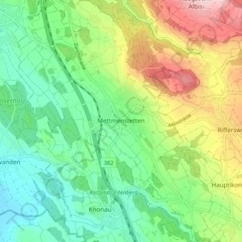
Nom : Carte topographique Mettmenstetten, altitude, relief.
Lieu : Mettmenstetten, Bezirk Affoltern, Zurich, 8932, Switzerland (47.21838 8.43208 47.26832 8.50067)
Altitude moyenne : 506 m
Altitude minimum : 389 m
Altitude maximum : 727 m
The municipality includes the village of Mettmenstetten, with the two core sections of Ober- and Untermettmenstetten as well as the other sections; Dachlissen, Eigi, Grossholz, Herferswil, Hübscheren, Rossau and Wissenbach. It is located an elevation of 460 m (1,510 ft).
Autres cartes topographiques
Cliquez sur une carte pour visualiser sa topographie, son altitude et son relief.
Aeugst am Albis
Switzerland > Zurich > Bezirk Affoltern
Aeugst am Albis, Bezirk Affoltern, Zurich, Switzerland
Altitude moyenne : 668 m
Wängibad
Switzerland > Zurich > Bezirk Affoltern > Aeugst am Albis
Wängibad, Aeugst am Albis, Bezirk Affoltern, Zurich, 8914, Switzerland
Altitude moyenne : 595 m