
Faire un don
Équipez-vous pour votre prochaine aventure :
En tant que Partenaire Amazon, ce site perçoit une commission sur les achats éligibles sans surcoût pour vous.
Carte topographique Cherat
Cliquez sur la carte pour afficher l’altitude.
Faire un don
Équipez-vous pour votre prochaine aventure :
En tant que Partenaire Amazon, ce site perçoit une commission sur les achats éligibles sans surcoût pour vous.
Cherat
Cherat (Pashto: چېراټ) is a hill station dating from the 1860s that is located immediately above the villages of Chapri,Bakhti, Saleh Khana, Kotli Kalan and Dak Ismail Khel in the Nowshera District of Khyber-Pakhtunkhwa in Pakistan. Cherat lies 34 miles south east from the city of Peshawar at an elevation of 4,500 feet on the west of the Khattak range, which divides the district of Nowshera from Kohat District.
Faire un don
Équipez-vous pour votre prochaine aventure :
En tant que Partenaire Amazon, ce site perçoit une commission sur les achats éligibles sans surcoût pour vous.
À propos de cette carte
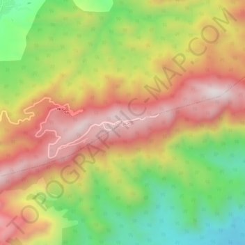
Nom : Carte topographique Cherat, altitude, relief.
Altitude moyenne : 986 m
Altitude minimum : 553 m
Altitude maximum : 1.380 m
Faire un don
Équipez-vous pour votre prochaine aventure :
En tant que Partenaire Amazon, ce site perçoit une commission sur les achats éligibles sans surcoût pour vous.