
Carte topographique Londonderry/Derry
Carte interactive
Cliquez sur la carte pour afficher l’altitude.
À propos de cette carte
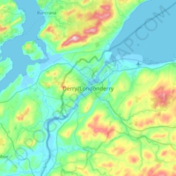
Nom : Carte topographique Londonderry/Derry, altitude, relief.
Altitude moyenne : 88 m
Altitude minimum : -5 m
Altitude maximum : 478 m
Autres cartes topographiques
Cliquez sur une carte pour visualiser sa topographie, son altitude et son relief.
River Ness
Verenigd Koninkrijk > Noord-Ierland > County Londonderry > Derry/Londonderry
River Ness, Derry/Londonderry, County Londonderry, Noord-Ierland, BT47 3EY, Verenigd Koninkrijk
Altitude moyenne : 120 m
Spingfield
Verenigd Koninkrijk > Noord-Ierland > County Londonderry
Spingfield, County Londonderry, Noord-Ierland, BT45 6HX, Verenigd Koninkrijk
Altitude moyenne : 55 m