
Carte topographique Durack
Carte interactive
Cliquez sur la carte pour afficher l’altitude.
À propos de cette carte
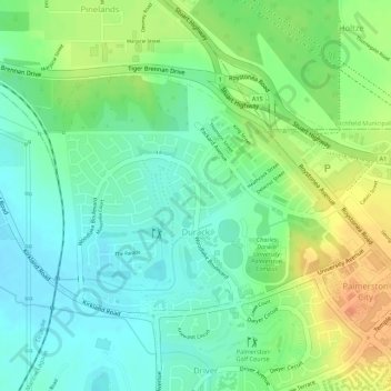
Nom : Carte topographique Durack, altitude, relief.
Lieu : Durack, City of Palmerston, Northern Territory, Australia (-12.48089 130.96186 -12.46426 130.98211)
Altitude moyenne : 26 m
Altitude minimum : 8 m
Altitude maximum : 51 m
Autres cartes topographiques
Cliquez sur une carte pour visualiser sa topographie, son altitude et son relief.
Woodroffe
Australia > City of Palmerston
Woodroffe, City of Palmerston, Northern Territory, 0830, Australia
Altitude moyenne : 24 m
Palmerston
Australia > City of Palmerston
Palmerston, City of Palmerston, Northern Territory, 0830, Australia
Altitude moyenne : 25 m
Driver
Australia > City of Palmerston > Palmerston
Driver, Palmerston, City of Palmerston, Northern Territory, 0830, Australia
Altitude moyenne : 25 m
Bakewell
Australia > City of Palmerston > Palmerston
Bakewell, Palmerston, City of Palmerston, Northern Territory, 0830, Australia
Altitude moyenne : 26 m
Moulden
Australia > City of Palmerston
Moulden, City of Palmerston, Northern Territory, Australia
Altitude moyenne : 19 m
Gray
Australia > City of Palmerston > Palmerston
Gray, Palmerston, City of Palmerston, Northern Territory, 0830, Australia
Altitude moyenne : 31 m
Gunn
Australia > City of Palmerston
Gunn, City of Palmerston, Northern Territory, Australia
Altitude moyenne : 32 m
Zuccoli
Australia > City of Palmerston
Zuccoli, City of Palmerston, Northern Territory, Australia
Altitude moyenne : 18 m
Palmerston City
Australia > City of Palmerston
Palmerston City, City of Palmerston, Northern Territory, Australia
Altitude moyenne : 33 m