
Carte topographique Crystal Beach
Cliquez sur la carte pour afficher l’altitude.
À propos de cette carte
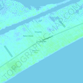
Nom : Carte topographique Crystal Beach, altitude, relief.
Lieu : Crystal Beach, Galveston County, Texas, 77600, United States (29.43726 -94.65891 29.47726 -94.61891)
Altitude moyenne : 1 m
Altitude minimum : -4 m
Altitude maximum : 7 m
Autres cartes topographiques
Cliquez sur une carte pour visualiser sa topographie, son altitude et son relief.
Galveston
United States > Texas > Galveston County
On September 8, 1900, the island was struck by a devastating hurricane. This event holds the record as the United States' deadliest natural disaster. The city was devastated, and an estimated 6,000 to 8,000 people on the island were killed. Following the storm, a 10-mile (16 km) long, 17 foot (5.2 m) high…
Altitude moyenne : 1 m
Texas City
United States > Texas > Galveston County
Officially, the elevation of Texas City is 10 feet above sea level, though some areas are even lower. It was naturally vulnerable to flooding by hurricane storm surges and heavy rainstorms.
Altitude moyenne : 2 m
Texas City
United States > Texas > Galveston County
Officially, the elevation of Texas City is 10 feet above sea level, though some areas are even lower. It was naturally vulnerable to flooding by hurricane storm surges and heavy rainstorms.
Altitude moyenne : 2 m
Galveston
United States > Texas > Galveston County
On September 8, 1900, the island was struck by a devastating hurricane. This event holds the record as the United States' deadliest natural disaster. The city was devastated, and an estimated 6,000 to 8,000 people on the island were killed. Following the storm, a 10-mile (16 km) long, 17 foot (5.2 m) high…
Altitude moyenne : 1 m
Texas City
United States > Texas > Galveston County
Officially, the elevation of Texas City is 10 feet above mean sea level, though some areas are even lower. It was naturally vulnerable to flooding by hurricane storm surges and heavy rainstorms.
Altitude moyenne : 2 m
Galveston
United States > Texas > Galveston County
On September 8, 1900, the island was struck by a devastating hurricane. This event holds the record as the United States' deadliest natural disaster. The city was devastated, and an estimated 6,000 to 8,000 people on the island were killed. Following the storm, a 10-mile (16 km) long, 17 foot (5.2 m) high…
Altitude moyenne : 1 m
Galveston
United States > Texas > Galveston County
On September 8, 1900, the island was struck by a devastating hurricane. This event holds the record as the United States' deadliest natural disaster. The city was devastated, and an estimated 6,000 to 8,000 people on the island were killed. Following the storm, a 10-mile (16 km) long, 17 foot (5.2 m) high…
Altitude moyenne : 1 m