
Carte topographique Massachusetts
Carte interactive
Cliquez sur la carte pour afficher l’altitude.
À propos de cette carte
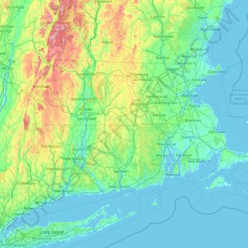
Nom : Carte topographique Massachusetts, altitude, relief.
Lieu : Massachusetts, United States (41.18886 -73.50821 42.88678 -69.86010)
Altitude moyenne : 128 m
Altitude minimum : -7 m
Altitude maximum : 1.159 m
Despite its small size, Massachusetts features numerous topographically distinctive regions. The large coastal plain of the Atlantic Ocean in the eastern section of the state contains Greater Boston, along with most of the state's population, as well as the distinctive Cape Cod peninsula. To the west lies the hilly, rural region of Central Massachusetts, and beyond that, the Connecticut River Valley. Along the western border of Western Massachusetts lies the highest elevated part of the state, the Berkshires, forming a portion of the northern terminus of the Appalachian Mountains.
Autres cartes topographiques
Cliquez sur une carte pour visualiser sa topographie, son altitude et son relief.
Brooklyn
United States > New York > New York
Brooklyn, Kings County, New York, United States
Altitude moyenne : 9 m
New Orleans
United States > Louisiana > Orleans Parish
New Orleans, Orleans Parish, Louisiana, United States
Altitude moyenne : 1 m
Albuquerque
United States > New Mexico > Bernalillo County
Albuquerque, Bernalillo County, New Mexico, United States
Altitude moyenne : 1.688 m
Houston
United States > Texas > Harris County
Houston, Harris County, Texas, United States
Altitude moyenne : 25 m
Santa Cruz
United States > California > Santa Cruz County
Santa Cruz, Santa Cruz County, California, United States
Altitude moyenne : 89 m
Sacramento
United States > California > Sacramento County
Sacramento, Sacramento County, California, United States
Altitude moyenne : 10 m
Jacksonville
United States > Florida > Duval County
Jacksonville, Duval County, Florida, United States
Altitude moyenne : 10 m
Queens County
United States > New York > New York
Queens County, New York, United States
Altitude moyenne : 11 m
Somerville
United States > Massachusetts > Middlesex County
Somerville, Middlesex County, Massachusetts, United States
Altitude moyenne : 11 m
Spokane
United States > Washington > Spokane County
Spokane, Spokane County, Washington, United States
Altitude moyenne : 655 m
Lexington
United States > Kentucky > Lexington
Lexington, Fayette County, Kentucky, 40508, United States
Altitude moyenne : 285 m
Madison
United States > Wisconsin > Dane County
Madison, Dane County, Wisconsin, United States
Altitude moyenne : 284 m
Santa Fe
United States > New Mexico > Santa Fe County
Santa Fe, Santa Fe County, New Mexico, United States
Altitude moyenne : 2.221 m
Kauai
United States > Hawaii > Kauaʻi County
Kauai, Kauaʻi County, Hawaii, United States
Altitude moyenne : 216 m
Staten Island
United States > New York > New York
Staten Island, Richmond County, New York, United States
Altitude moyenne : 9 m
Baltimore
United States > Maryland > Baltimore
Baltimore, Maryland, 21233, United States
Altitude moyenne : 65 m
Lancaster County
Lancaster County, Pennsylvania, United States
Altitude moyenne : 158 m
Fairfax County
Fairfax County, Virginia, United States
Altitude moyenne : 75 m
Lehigh County
Lehigh County, Pennsylvania, United States
Altitude moyenne : 186 m