
Carte topographique Addis Ababa
Carte interactive
Cliquez sur la carte pour afficher l’altitude.
Addis Ababa
Addis Ababa lies at an elevation of 2,355 metres (7,726 ft) and is a grassland biome, located at 9°1′48″N 38°44′24″E / 9.03000°N 38.74000°E / 9.03000; 38.74000. The city lies at the foot of Mount Entoto and forms part of the watershed for the Awash. From its lowest point, around Bole International Airport, at 2,326 metres (7,631 ft) above sea level in the southern periphery, Addis Ababa rises to over 3,000 metres (9,800 ft) in the Entoto Mountains to the north.
À propos de cette carte
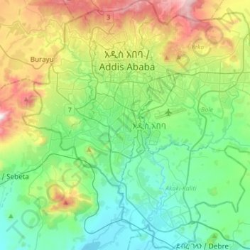
Nom : Carte topographique Addis Ababa, altitude, relief.
Lieu : Addis Ababa, Ethiopia (8.83311 38.63990 9.09858 38.90805)
Altitude moyenne : 2.371 m
Altitude minimum : 2.044 m
Altitude maximum : 3.195 m
Autres cartes topographiques
Cliquez sur une carte pour visualiser sa topographie, son altitude et son relief.
Metu
Metu (Oromo: Mattuu) is a market town and separate woreda in south-western Ethiopia. Located in the Illubabor Zone of the Oromia along the Sor River, this town has a latitude and longitude of 8°18′N 35°35′E / 8.300°N 35.583°E / 8.300; 35.583 and an altitude of 1605 meters. Metu was the capital…
Altitude moyenne : 1.682 m
Debre Birhan
Debre Birhan (Amharic: ደብረ ብርሃን) is a city in central Ethiopia. Located in the Semien Shewa Zone of Amhara Region, about 120 kilometers north east of Addis Ababa on Ethiopian highway 2, the town has an elevation of 2,840 meters, which makes it the highest town in Africa. It was an early capital…
Altitude moyenne : 2.720 m
Entoto
Ethiopia > Oromia Region > Sululta
The Ethiopian Heritage Trust, a non-profit, non-governmental organization, is working actively to change part of the mountain to its old state, a natural park. Entoto Natural Park is the northeastern rim of Addis Abeba, on the southeastern slopes of Mt. Entoto, covering an area of 1,300 hectares. It is…
Altitude moyenne : 3.019 m
Chiro
Chiro (also called Asebe Teferi or Asba Littoria; Afaan Oromo: Ciroo) is a town and Aanaa in eastern Ethiopia. Located in the West Hararghe Zone in Oromia Regional State, Ethiopia Ahmar Mountains, it has a latitude and longitude of 9°05′N 40°52′E / 9.083°N 40.867°E / 9.083; 40.867 and an…
Altitude moyenne : 1.870 m
Harena Forest
The Harenna Forest is a montane tropical evergreen forest in Ethiopia's Bale Mountains. The forest covers the southern slope of the mountains, extending from 1450 to 3200 meters elevation. The Bale Mountains are in Ethiopia's Oromia Region, and form the southwestern portion of the Ethiopian Highlands.
Altitude moyenne : 2.028 m
Ogaden Desert
The Ogaden is a plateau, with an elevation above sea level that ranges from 1,500 metres (4,900 ft) in the northwest, falling to about 300 metres (980 ft) along the southern limits and the Wabi Shebelle valley. The areas with altitudes between 1,400 and 1,600 metres (4,600 and 5,200 ft) are characterised as…
Altitude moyenne : 584 m
Metemma
Metemma (Amharic: መተማ), also known as Metemma Yohannes, is a town in northwestern Ethiopia, on the border with Sudan. Located in the Semien Gondar Zone of the Amhara Region, Metemma has a latitude and longitude of 12°58′N 36°12′E / 12.967°N 36.200°E / 12.967; 36.200 with an elevation of…
Altitude moyenne : 738 m
Hawassa
Hawassa (Amharic: አዋሳ; ʾäwasa, also spelled Awassa or Awasa) known historically as Adare is a city in Ethiopia, on the shores of Lake Awassa in the Great Rift Valley. It is 273 km (170 mi) south of Addis Ababa via Bishoftu, 130 km (81 mi) east of Sodo, and 75 km (47 mi) north of Dilla. The town serves…
Altitude moyenne : 1.862 m
Sire
Sire (also transliterated "Sirie") is a town in south-western Oromia. Located in the Arsi Zone of the Oromia, Ethiopia. This town has a latitude and longitude of 08°17′N 39°27′E / 8.283°N 39.450°E / 8.283; 39.450 with an altitude of 1793 meters above sea level. It is administrative center of…
Altitude moyenne : 2.033 m
Asassa
Asasa is a town in southeastern Ethiopia. Located in the West Arsi Zone of the Oromia Region, this town has a latitude and longitude of 07°06′N 39°12′E / 7.100°N 39.200°E / 7.100; 39.200 with an elevation of 2367 meters above sea level. It is the administrative center of Gedeb Asasa woreda.
Altitude moyenne : 2.382 m
Moyale
Moyale has a hot semi-arid climate (Köppen BSh) moderated somewhat by altitude. Typically for East Africa, there are two rainy seasons: the “long rains” from March to May and the weaker, less reliable “short rains” in October and November.
Altitude moyenne : 1.095 m
Wolaita Sodo
Ethiopia > South Ethiopia Regional State
Sodo (Amharic: ሶዶ) or officially Wolaita Sodo (Amharic: ወላይታ ሶዶ, Wolaytta: Wolaytta Sooddo) is a city in south Ethiopia. The City is a political and administrative center of the Wolaita Zone and South Ethiopia Regional State. It has a latitude and longitude of 6°54′N 37°45′E /…
Altitude moyenne : 1.873 m
Dessie
Dessie (Amharic: ደሴ, romanized: Däse; also spelled Dese or Dessye) is a town in north-central Ethiopia. Located in the South Wollo Zone of the Amhara Region, it sits at a latitude and longitude of 11°8′N 39°38′E / 11.133°N 39.633°E / 11.133; 39.633, with an elevation between 2,470 and…
Altitude moyenne : 2.450 m
Alamata
Alamata (Tigrinya: ኣላማጣ ) is a town in the Tigray Region of Ethiopia. Located in the Debubawi (Southern) zone of Tigray it has a latitude and longitude of 12°25′N 39°33′E / 12.417°N 39.550°E / 12.417; 39.550 and an elevation of 1,520 metres (4,990 ft) above sea level and is located…
Altitude moyenne : 1.574 m
Addis Ababa
Ethiopia > Addis Ababa > Arada
Moreover, the city held strong social organizations pattern prior Italian invasion. According to Richard Pankhurst (1968), the city accelerated population growth due to factors of provisional governors and their troops, the 1892 famine, eventually the Battle of Adwa. Another include the 1907 land act,…
Altitude moyenne : 2.517 m
Adwa
Adwa (Tigrinya: ዓድዋ; Amharic: ዐድዋ; also spelled Adowa or Aduwa) is a town and separate woreda in Tigray Region, Ethiopia. It is best known as the community closest to the site of the 1896 Battle of Adwa, in which Ethiopian soldiers defeated Italian troops, thus being one of the few African nations…
Altitude moyenne : 1.962 m
Agaro
Agaro (also spelled Haggaro) (Oromo: Aggaaroo) is a town and separate woreda in south-western Ethiopia. Located in the Jimma Zone of the Oromia Region, it sits at an elevation of 1,560 meters above sea level.
Altitude moyenne : 1.677 m
Wolaita Sodo
Ethiopia > South Ethiopia Regional State
Sodo (Amharic: ሶዶ) or officially Wolaita Sodo (Amharic: ወላይታ ሶዶ, Wolaytta: Wolaytta Sooddo) is a city in south Ethiopia. The City is a political and administrative center of the Wolaita Zone and South Ethiopia Regional State. It has a latitude and longitude of 6°54′N 37°45′E /…
Altitude moyenne : 1.873 m
Sokoru
The altitude of this woreda ranges from 1160 to 2940 meters above sea level; the highest points include Ali Shashema, Ali Derar and Kumbi. Perennial rivers include the Gilgel Gibe a tributary of the Gibe, and the Kawar; seasonal streams include the Melka Luku. A survey of the land in this woreda shows that…
Altitude moyenne : 1.827 m
Waliso
Waliso (Oromo: Walisoo) is a town in Southwest Shewa Zone of the Oromia Region in Ethiopia, 114 km southwest of Addis Ababa, it has a latitude and longitude of 8°32′N 37°58′E / 8.533°N 37.967°E / 8.533; 37.967 with an elevation of 2063 meters above sea level. Waliso is the administrative center of this Zone.
Altitude moyenne : 2.044 m
Adama
Ethiopia > Oromia Region > Adama
Adama (Oromo: Adaamaa or Hadaamaa, Amharic: አዳማ), formerly Nazreth (Amharic: ናዝሬት), is a city in central Oromia Region, Ethiopia. Adama forms a Special Zone of Oromia and is surrounded by East Shewa Zone. It is located at 8°32′N 39°16′E / 8.54°N 39.27°E / 8.54; 39.27 at an…
Altitude moyenne : 1.673 m
Lake Hawassa
Lake Hawassa or Awasa, is an endorheic basin in Sidama Region of Ethiopia, located in the Main Ethiopian Rift south of Addis Ababa, the capital city of the country. According to the Statistical Abstract of Ethiopia for 1967/68, the lake is 16 km long and 9 km wide, with a surface area of 129 square kilometers.…
Altitude moyenne : 1.705 m
Waliso
Waliso (Oromo: Walisoo) is a town in Southwest Shewa Zone of the Oromia Region in Ethiopia, 114 km southwest of Addis Ababa, it has a latitude and longitude of 8°32′N 37°58′E / 8.533°N 37.967°E / 8.533; 37.967 with an elevation of 2063 meters above sea level. Waliso is the administrative center of this Zone.
Altitude moyenne : 2.044 m
Debre Work
Debre Werq (Amharic: ደብረ ወርቅ) is a small town in western Ethiopia. Located in the East Gojjam of the Amhara Region, it has a latitude and longitude of 6°52′N 35°31′E / 6.867°N 35.517°E / 6.867; 35.517 with an elevation of 2489 meters above sea level. The settlement is known for its…
Altitude moyenne : 2.556 m