
Carte topographique Reno
Carte interactive
Cliquez sur la carte pour afficher l’altitude.
À propos de cette carte
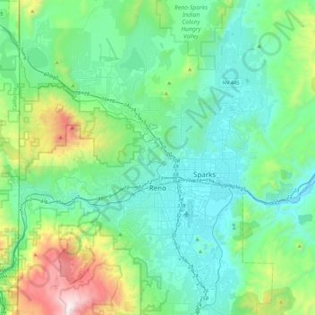
Nom : Carte topographique Reno, altitude, relief.
Lieu : Reno, Washoe County, Nevada, United States (39.39243 -120.00233 39.72344 -119.69935)
Altitude moyenne : 1.650 m
Altitude minimum : 1.316 m
Altitude maximum : 3.010 m
Reno is just east of the Sierra Nevada, on the western edge of the Great Basin at an elevation of about 4,400 feet (1,300 m) above sea level. Numerous faults exist throughout the region. Most of these are normal (vertical motion) faults associated with the uplift of the various mountain ranges, including the Sierra Nevada.
Autres cartes topographiques
Cliquez sur une carte pour visualiser sa topographie, son altitude et son relief.
Cold Springs
United States > Nevada > Washoe County
Cold Springs, Washoe County, Nevada, 89508, United States
Altitude moyenne : 1.573 m
Nixon
United States > Nevada > Washoe County
Nixon, Washoe County, Nevada, 89424, United States
Altitude moyenne : 1.209 m
Incline Village-Crystal Bay
United States > Nevada > Washoe County
Incline Village-Crystal Bay, Washoe County, Nevada, United States
Altitude moyenne : 2.173 m
Sparks
United States > Nevada > Washoe County
Sparks, Washoe County, Nevada, United States
Altitude moyenne : 1.438 m
Oxbow Nature Study Area
United States > Nevada > Washoe County > Reno > West Reno
Oxbow Nature Study Area, West Reno, Reno, Washoe County, Nevada, United States
Altitude moyenne : 1.415 m
Pyramid Lake
United States > Nevada > Washoe County
Pyramid Lake, Washoe County, Nevada, United States
Altitude moyenne : 1.406 m
North Valley
United States > Nevada > Washoe County > Reno
North Valley, Reno, Washoe County, Nevada, 89512, United States
Altitude moyenne : 1.419 m
New Washoe City
United States > Nevada > Washoe County
New Washoe City, Washoe Valley CCD, Washoe County, Nevada, United States
Altitude moyenne : 1.589 m