
Carte topographique Kurnool
Carte interactive
Cliquez sur la carte pour afficher l’altitude.
À propos de cette carte
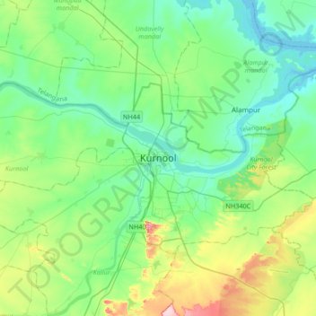
Nom : Carte topographique Kurnool, altitude, relief.
Lieu : Kurnool, Andhra Pradesh, 518001, India (15.67093 77.88254 15.99093 78.20254)
Altitude moyenne : 307 m
Altitude minimum : 259 m
Altitude maximum : 453 m
Kurnool is located at 15°50′00″N 78°03′00″E / 15.8333°N 78.05°E / 15.8333; 78.05. It has an average elevation of 273 metres (898 feet). Kurnool lies on the banks of the Tungabhadra River. The Hundri and Neeva rivers also flow through the city. The K.C.Canal (Kurnool–Cuddapah) was built by the Dutch for transportation, but later used for irrigation.