
Carte topographique Delta County
Carte interactive
Cliquez sur la carte pour afficher l’altitude.
À propos de cette carte
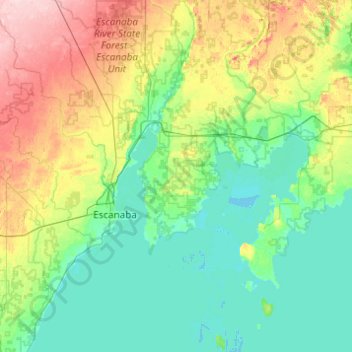
Nom : Carte topographique Delta County, altitude, relief.
Lieu : Delta County, Michigan, États-Unis (45.47733 -87.36765 46.15910 -86.45908)
Altitude moyenne : 210 m
Altitude minimum : 172 m
Altitude maximum : 334 m
Autres cartes topographiques
Cliquez sur une carte pour visualiser sa topographie, son altitude et son relief.
Pontiac
États-Unis > Michigan > Pontiac
Pontiac, Oakland County, Michigan, États-Unis
Altitude moyenne : 290 m
Oakland Charter Township
États-Unis > Michigan > Oakland Charter Township
Oakland Charter Township, Oakland County, Michigan, États-Unis
Altitude moyenne : 284 m