Géolocaliser

Carte topographique Koshi

Carte interactive

Cliquez sur la carte pour afficher l’altitude.

À propos de cette carte

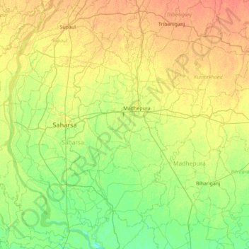
Nom : Carte topographique Koshi, altitude, relief.

Lieu : Koshi, Madhepura, Bihar, 852218, Inde (25.56630 86.67474 26.18387 86.81117)

Altitude moyenne : 45 m

Altitude minimum : 31 m

Altitude maximum : 61 m

Autres cartes topographiques

Cliquez sur une carte pour visualiser sa topographie, son altitude et son relief.

Ander

Inde > Bihar > Andar

Ander, Andar, Siwan District, Bihar, Inde

Altitude moyenne : 61 m

Amas

Inde > Bihar > Amas

Amas, Gaya, Bihar, 824212, Inde

Altitude moyenne : 173 m

Siwan

Inde > Bihar

Siwan, Bihar, Inde

Altitude moyenne : 62 m

Koshi

Inde > Bihar

Koshi, Bihar, 852101, Inde

Altitude moyenne : 82 m

Bagmati River

Inde > Bihar

Bagmati River, Muzaffarpur, Bihar, 843321, Inde

Altitude moyenne : 422 m

Siwān

Inde > Bihar

Siwān, Siwan, Bihar, Inde

Altitude moyenne : 63 m