
Carte topographique Abi Gamin
Carte interactive
Cliquez sur la carte pour afficher l’altitude.
À propos de cette carte
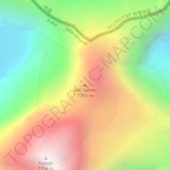
Nom : Carte topographique Abi Gamin, altitude, relief.
Lieu : Abi Gamin, Chamoli, Uttarakhand, Inde (30.93174 79.59993 30.93184 79.60003)
Altitude moyenne : 6.721 m
Altitude minimum : 5.877 m
Altitude maximum : 7.675 m
Autres cartes topographiques
Cliquez sur une carte pour visualiser sa topographie, son altitude et son relief.
Badrinath
Inde > Uttarakhand > Joshimath Tehsil
Badrinath, Joshimath Tehsil, Chamoli District, Uttarakhand, Inde
Altitude moyenne : 4.052 m
Chamoli
Inde > Uttarakhand > Chamoli Tehsil
Chamoli, Chamoli Tehsil, Chamoli District, Uttarakhand, 246426, Inde
Altitude moyenne : 1.425 m
Dehradun
Inde > Uttarakhand > Dehradun > Dehradun
Dehradun, Uttarakhand, 248001, Inde
Altitude moyenne : 904 m
Barrage
Inde > Uttarakhand > Barrage
Barrage, Dehradun, Uttarakhand, 249201, Inde
Altitude moyenne : 361 m
Chaumail
Inde > Uttarakhand > Chaumail
Chaumail, Champawat, Uttarakhand, 262524, Inde
Altitude moyenne : 1.657 m
Tehri-Garhwal
Tehri-Garhwal, Tehri Garhwal, Uttarakhand, 249125, Inde
Altitude moyenne : 2.339 m
Bhagirathi River
Bhagirathi River, Uttarkashi, Uttarakhand, 249151, Inde
Altitude moyenne : 2.258 m