
Carte topographique Tauranga City
Carte interactive
Cliquez sur la carte pour afficher l’altitude.
À propos de cette carte
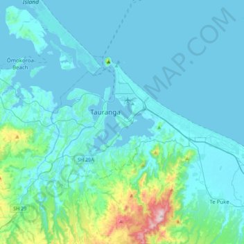
Nom : Carte topographique Tauranga City, altitude, relief.
Lieu : Tauranga City, Bay of Plenty, Nouvelle-Zélande (-37.77056 176.07411 -37.62318 176.41504)
Altitude moyenne : 55 m
Altitude minimum : -1 m
Altitude maximum : 544 m
Autres cartes topographiques
Cliquez sur une carte pour visualiser sa topographie, son altitude et son relief.
Parinui
Nouvelle-Zélande > Bay of Plenty > Ōpōtiki District
Parinui, Ōpōtiki District, Bay of Plenty, 3162, Nouvelle-Zélande
Altitude moyenne : 67 m
Whakatāne District
Nouvelle-Zélande > Bay of Plenty
Whakatāne District, Bay of Plenty, Nouvelle-Zélande
Altitude moyenne : 416 m
Rotorua Lakes District
Nouvelle-Zélande > Bay of Plenty
Rotorua Lakes District, Bay of Plenty, Nouvelle-Zélande
Altitude moyenne : 404 m
Mount Tarawera
Nouvelle-Zélande > Bay of Plenty > Rotorua
Mount Tarawera, Rotorua, Rotorua District, Bay of Plenty, Nouvelle-Zélande
Altitude moyenne : 894 m
Mayor Island / Tuhua
Nouvelle-Zélande > Bay of Plenty > Tauranga
Mayor Island / Tuhua, Tauranga, Bay of Plenty, Nouvelle-Zélande
Altitude moyenne : 71 m
Lake Ōkataina
Nouvelle-Zélande > Bay of Plenty > Ruato
Lake Ōkataina, Eastern Okataina Walkway, Ruato, Rotorua District, Bay of Plenty, Nouvelle-Zélande
Altitude moyenne : 440 m
Koranga River
Nouvelle-Zélande > Bay of Plenty > Ōpōtiki District
Koranga River, Ōpōtiki District, Bay of Plenty, Nouvelle-Zélande
Altitude moyenne : 582 m
Rotorua
Nouvelle-Zélande > Bay of Plenty > Rotorua
Rotorua, Rotorua District, Bay of Plenty, 3010, Nouvelle-Zélande
Altitude moyenne : 435 m