
Carte topographique Pemalang
Carte interactive
Cliquez sur la carte pour afficher l’altitude.
À propos de cette carte
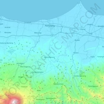
Nom : Carte topographique Pemalang, altitude, relief.
Lieu : Pemalang, Java central, Jawa, Indonésie (-7.24889 109.18559 -6.77331 109.59920)
Altitude moyenne : 295 m
Altitude minimum : -1 m
Altitude maximum : 3.408 m
Autres cartes topographiques
Cliquez sur une carte pour visualiser sa topographie, son altitude et son relief.
Buret
Indonésie > Java central > Purbalingga
Buret, Purbalingga, Java central, Jawa, 53356, Indonésie
Altitude moyenne : 452 m
Mojosongo
Indonésie > Java central > Boyolali
Mojosongo, Boyolali, Java central, Jawa, 57322, Indonésie
Altitude moyenne : 318 m
Karanganyar
Karanganyar, Java central, Jawa, Indonésie
Altitude moyenne : 408 m
Telomoyo
Telomoyo, Magelang, Java central, 56194, Indonésie
Altitude moyenne : 1.386 m
RW 01
Indonésie > Java central > Semarang > Kauman
RW 01, Kauman, Semarang Tengah, Semarang, Java central, 50137, Indonésie
Altitude moyenne : 8 m
Gunung Sindoro
Indonésie > Java central > Magelang
Gunung Sindoro, Magelang, Java central, Indonésie
Altitude moyenne : 2.572 m
Puncak Trianggulasi
Indonésie > Java central > Jrakah
Puncak Trianggulasi, Jrakah, Java central, Indonésie
Altitude moyenne : 2.696 m
Bulusan
Indonésie > Java central > Semarang
Bulusan, Tembalang, Semarang, Java central, 50277, Indonésie
Altitude moyenne : 140 m