
Carte topographique Kargaly District
Carte interactive
Cliquez sur la carte pour afficher l’altitude.
À propos de cette carte
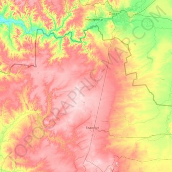
Nom : Carte topographique Kargaly District, altitude, relief.
Lieu : Kargaly District, Aktobe Region, 030500, Kazakhstan (50.44843 57.28367 51.16228 58.87799)
Altitude moyenne : 325 m
Altitude minimum : 157 m
Altitude maximum : 510 m
Autres cartes topographiques
Cliquez sur une carte pour visualiser sa topographie, son altitude et son relief.
Khromtau
Kazakhstan > Aktobe Region > Khromtau District
Khromtau, Khromtau District, Aktobe Region, 031100, Kazakhstan
Altitude moyenne : 423 m
Mugalzhar District
Mugalzhar District, Aktobe Region, Kazakhstan
Altitude moyenne : 279 m
Badamsha
Kazakhstan > Aktobe Region > Kargaly District > Badamsha
Badamsha, Kargaly District, Aktobe Region, 030500, Kazakhstan
Altitude moyenne : 425 m
Yrgyz District
Kazakhstan > Aktobe Region > Yrgyz District
Yrgyz District, Aktobe Region, 030400, Kazakhstan
Altitude moyenne : 129 m
Aktobe
Kazakhstan > Aktobe Region > Aktobe
Aktobe, Актобе Г.А., Aktobe Region, 030000, Kazakhstan
Altitude moyenne : 240 m