
Carte topographique Sikkim
Carte interactive
Cliquez sur la carte pour afficher l’altitude.
À propos de cette carte
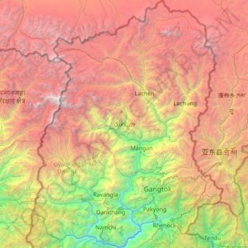
Nom : Carte topographique Sikkim, altitude, relief.
Lieu : Sikkim, Inde (27.07940 88.01203 28.12264 88.92137)
Altitude moyenne : 3.786 m
Altitude minimum : 264 m
Altitude maximum : 8.447 m
Le Sikkim, État en forme de pouce enfoncé entre le Tibet, le Népal et le Bhoutan, est caractérisé par un relief globalement montagneux. Presque tout l'État est vallonné, avec une altitude allant de 280 à 8 598 mètres. Le sommet du Kangchenjunga (8 598 m), situé à cheval sur le Sikkim et le Népal, est le troisième plus haut sommet du monde et le point culminant de l'Inde.
Autres cartes topographiques
Cliquez sur une carte pour visualiser sa topographie, son altitude et son relief.
Bhagsu
Inde > Himachal Pradesh > Dharamshala
Bhagsu, Dharamshala, Kangra District, Himachal Pradesh, 176219, Inde
Altitude moyenne : 1.955 m
Chiplun
Inde > Maharashtra > Chiplun
Chiplun, Ratnagiri, Maharashtra, 415600, Inde
Altitude moyenne : 69 m
Wan
Inde > Jammu-et-Cachemire > Doda
Wan, Doda, Doda District, Jammu-et-Cachemire, Inde
Altitude moyenne : 1.186 m
Balaya
Inde > Rajasthan > Mundwa Tehsil
Balaya, Mundwa Tehsil, Nagaur District, Rajasthan, Inde
Altitude moyenne : 320 m
Srinagar
Inde > Jammu-et-Cachemire > Srinagar (South)
Srinagar, Srinagar (South), Srinagar District, Jammu-et-Cachemire, 190001, Inde
Altitude moyenne : 1.805 m
Buhan
Inde > Arunachal Pradesh > Koloriang HQ > Koloriang
Buhan, Koloriang, Koloriang HQ, Kurung Kumey District, Arunachal Pradesh, Inde
Altitude moyenne : 1.485 m
Salwan
Inde > Maharashtra > Sangrampur > Kamod
Salwan, Kamod, Sangrampur, Buldhana, Maharashtra, Inde
Altitude moyenne : 390 m
Thol
Inde > Haryana > Ismailabad
Thol, Ismailabad, Kurukshetra District, Haryana, 136136, Inde
Altitude moyenne : 258 m
Chamoni Gaon
Inde > Assam > Chabua > Khagorimaijan
Chamoni Gaon, Khagorimaijan, Chabua, Dibrugarh District, Assam, 786101, Inde
Altitude moyenne : 113 m
Jashpur Tahsil
Jashpur Tahsil, Jashpur District, Chhattisgarh, Inde
Altitude moyenne : 712 m
Namche
Inde > Ladakh > Kargil tehsil
Namche, Kargil tehsil, Kargil District, Ladakh, Inde
Altitude moyenne : 3.861 m
Rara
Inde > Madhya Pradesh > Nagod Tahsil > Rara
Rara, Nagod Tahsil, Satna District, Madhya Pradesh, Inde
Altitude moyenne : 329 m
Mantralayam
Inde > Andhra Pradesh > Mantralayam
Mantralayam, Kurnool District, Andhra Pradesh, 518345, Inde
Altitude moyenne : 326 m
Kudi
Inde > Madhya Pradesh > Khilchipur Tahsil > Kundibeh
Kudi, Kundibeh, Khilchipur Tahsil, Rajgarh District, Madhya Pradesh, Inde
Altitude moyenne : 427 m
Hyderabad
Inde > Telangana > Bahadurpura mandal
Hyderabad, Bahadurpura mandal, Hyderabad District, Telangana, Inde
Altitude moyenne : 549 m
Durgapur
Inde > Bengale-Occidental > Faridpur Durgapur
Durgapur, Faridpur Durgapur, Paschim Bardhaman District, Bengale-Occidental, 713200, Inde
Altitude moyenne : 76 m
Meka
Inde > Arunachal Pradesh > Roing HQ
Meka, Roing HQ, Lower Dibang Valley District, Arunachal Pradesh, Inde
Altitude moyenne : 294 m
Badrinath
Inde > Uttarakhand > Joshimath Tehsil
Badrinath, Joshimath Tehsil, Chamoli District, Uttarakhand, Inde
Altitude moyenne : 4.052 m
Ait
Inde > Uttar Pradesh > Orai
Ait, Orai, Jalaun, Uttar Pradesh, 285201, Inde
Altitude moyenne : 154 m
Antre
Inde > Maharashtra > Shevgaon
Antre, Shevgaon, Ahmednagar, Maharashtra, Inde
Altitude moyenne : 474 m
Patane
Inde > Maharashtra > Chandgad
Patane, Chandgad, Kolhapur, Maharashtra, Inde
Altitude moyenne : 721 m
Sayan
Inde > Gujarat > Olpad Taluka
Sayan, Olpad Taluka, Surat, Gujarat, 394130, Inde
Altitude moyenne : 18 m
Darjeeling
Inde > Bengale-Occidental > Darjeeling Pulbazar
Darjeeling, Darjeeling Pulbazar, Darjeeling District, Bengale-Occidental, 734101, Inde
Altitude moyenne : 1.324 m
Anantnag district
Anantnag district, Jammu-et-Cachemire, Inde
Altitude moyenne : 2.830 m
Chamoli
Inde > Uttarakhand > Chamoli Tehsil
Chamoli, Chamoli Tehsil, Chamoli District, Uttarakhand, 246426, Inde
Altitude moyenne : 1.425 m
Hassan
Inde > Karnataka > Hasana taluk
Hassan, Hasana taluk, Hassan District, Karnataka, 573201, Inde
Altitude moyenne : 949 m
Bardhaman
Inde > Bengale-Occidental > Burdwan - I
Bardhaman, Burdwan - I, Purba Bardhaman, Bengale-Occidental, Inde
Altitude moyenne : 31 m
Someshwara
Inde > Karnataka > Karkala taluk
Someshwara, Karkala taluk, Udupi district, Karnataka, 576129, Inde
Altitude moyenne : 214 m
Chara
Inde > Karnataka > Karkala taluk
Chara, Karkala taluk, Udupi district, Karnataka, 576112, Inde
Altitude moyenne : 65 m
Eiffel
Inde > Haryana > Gurugram District
Eiffel, Sohna, Gurugram District, Haryana, Inde
Altitude moyenne : 253 m
Dehradun
Inde > Uttarakhand > Dehradun > Dehradun
Dehradun, Uttarakhand, 248001, Inde
Altitude moyenne : 904 m
Bareli
Inde > Uttar Pradesh > Bareilly
Bareli, Bareilly, Bareilly District, Uttar Pradesh, 243001, Inde
Altitude moyenne : 170 m
Kolhapur
Inde > Maharashtra > Kolhapur > Kolhapur
Kolhapur, Maharashtra, 416003, Inde
Altitude moyenne : 592 m
Hyderabad
Inde > Telangana > Bahadurpura mandal > Hyderabad
Hyderabad, Bahadurpura mandal, Hyderabad, Telangana, 500 002, Inde
Altitude moyenne : 545 m
Bombay
Inde > Maharashtra > Bombay
Bombay, Mumbai Metropolitan Region, Mumbai Suburban, Maharashtra, Inde
Altitude moyenne : 18 m
Ambattur
Inde > Tamil Nadu > Ambattur
Ambattur, Thiruvallur District, Tamil Nadu, Inde
Altitude moyenne : 18 m