
Carte topographique Grand Forks
Carte interactive
Cliquez sur la carte pour afficher l’altitude.
À propos de cette carte
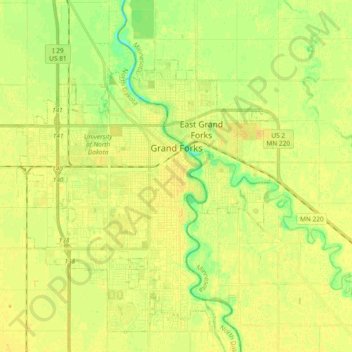
Nom : Carte topographique Grand Forks, altitude, relief.
Lieu : Grand Forks, Grand Forks County, North Dakota, United States (47.86017 -97.19588 47.96970 -97.00980)
Altitude moyenne : 255 m
Altitude minimum : 241 m
Altitude maximum : 263 m
Grand Forks is 74 miles (119 km) north of the Fargo-Moorhead area and 145 miles (233 km) south of Winnipeg, Manitoba. Grand Forks is on the western bank of the Red River of the North in an area known as the Red River Valley. The term "forks" refers to the forking of the Red River with the Red Lake River near downtown Grand Forks. According to the U.S. Census Bureau, the city has a total area of 20.09 square miles (52.03 km2), of which 19.91 square miles (51.57 km2) is land and 0.18 square miles (0.47 km2) is water. Since it is in one of the flattest parts of the world, the city has few differences in elevation. There are no lakes within the city limits of Grand Forks, but the meandering Red River and the English Coulee flow through the community and provide some break in the terrain.
Autres cartes topographiques
Cliquez sur une carte pour visualiser sa topographie, son altitude et son relief.
Reynolds
United States > North Dakota > Grand Forks County
Reynolds, Grand Forks County, North Dakota, United States
Altitude moyenne : 279 m
Niagara
United States > North Dakota > Grand Forks County > Niagara
Niagara, Grand Forks County, North Dakota, 58266, United States
Altitude moyenne : 437 m