Géolocaliser

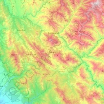
Carte topographique Solan

Cliquez sur la carte pour afficher l’altitude.

Solan

Solan is a city in the Indian state of Himachal Pradesh and the district headquarters of Solan district. It is located 45.5 kilometres (28 mi) south of the state capital, Shimla. Solan has an average elevation of 1,550 metres (5,090 ft). The city is situated between Chandigarh (joint capital of Punjab and Haryana) and Shimla (state capital) on the Kalka-Shimla National Highway-5. The narrow-gauge Kalka-Shimla railway passes through Solan. Located on the Punjab-Himachal Border, Solan is nestled in the Shivalik hills of the Himalayas.

Wikipedia (CC-BY-SA 3.0)

À propos de cette carte

Nom : Carte topographique Solan, altitude, relief.

Lieu : Solan, Himachal Pradesh, 173212, India (30.74776 76.94236 31.06776 77.26236)

Altitude moyenne : 1.312 m

Altitude minimum : 428 m

Altitude maximum : 2.558 m

Équipez-vous pour votre prochaine aventure :

Montres GPS randonnée - Montres robustes pour navigation et suivi outdoor
🧥Vestes coupe-vent - Protection contre le vent
🧴Gels Hydroalcooliques - Hygiène nomade facilitée
🎒Sacs à dos de randonnée - Sacs ergonomiques pour sorties à la journée ou en itinérance
🌂Parapluies Tempête - Robustesse testée pour le climat belge

En tant que Partenaire Amazon, ce site perçoit une commission sur les achats éligibles sans surcoût pour vous.