
Faire un don
Équipez-vous pour votre prochaine aventure :
En tant que Partenaire Amazon, ce site perçoit une commission sur les achats éligibles sans surcoût pour vous.
Carte topographique Šipovo
Cliquez sur la carte pour afficher l’altitude.
Faire un don
Équipez-vous pour votre prochaine aventure :
En tant que Partenaire Amazon, ce site perçoit une commission sur les achats éligibles sans surcoût pour vous.
Šipovo
In the geomorphologic sense, Šipovo is a mountain region whose average height is 800 metres above sea level. In the global climatic sense, Šipovo lies in temperately continental zone, with certain differences the reason for which being variations in height above sea level, as well as topographic and vegetational elements. The air temperature is the basic climatic element. The average annual temperature is 10˚C, the average summer temperature is 20˚C, and the average winter temperature is around 0˚C. The average annual insolation is 1800 hours, which makes five hours per day. The average annual humidity is around 85%. Precipitations are very important climatic element. The average value of annual precipitations is 990 mm. The average number of snowy days is 120, whereas the vegetational period lasts for about 250 days. There are a lot of foggy days in Šipovo. Winds are very often in the southern part of the area (Janjska visoravan) due to intermixing of the Mediterranean and continental air masses over Janj.
Faire un don
Équipez-vous pour votre prochaine aventure :
En tant que Partenaire Amazon, ce site perçoit une commission sur les achats éligibles sans surcoût pour vous.
À propos de cette carte
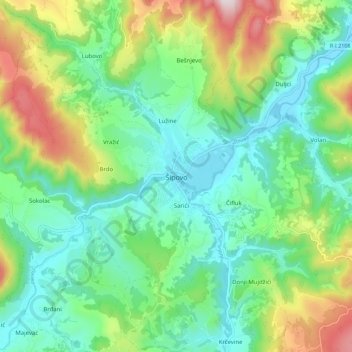
Nom : Carte topographique Šipovo, altitude, relief.
Altitude moyenne : 612 m
Altitude minimum : 430 m
Altitude maximum : 1.039 m
Faire un don
Équipez-vous pour votre prochaine aventure :
En tant que Partenaire Amazon, ce site perçoit une commission sur les achats éligibles sans surcoût pour vous.
Autres cartes topographiques
Cliquez sur une carte pour visualiser sa topographie, son altitude et son relief.
Ravna planina
Bosnia and Herzegovina > Republika Srpska > City of Istočno Sarajevo > Gornje Pale
Altitude moyenne : 1.265 m
Faire un don
Équipez-vous pour votre prochaine aventure :
En tant que Partenaire Amazon, ce site perçoit une commission sur les achats éligibles sans surcoût pour vous.
Rakovac
Bosnia and Herzegovina > Republika Srpska > City of Istočno Sarajevo > Rakovac
Altitude moyenne : 927 m
Prijedor
Bosnia and Herzegovina > Republika Srpska > City of Prijedor
The urban centre of Prijedor, within the city of Prijedor, is located in the northwestern part of Bosnia and Herzegovina, on the banks of the Sana and Gomjenica rivers, and at the southwestern hills of the Kozara mountain. The area of the municipality is 833 square kilometres (322 square miles). The town is…
Altitude moyenne : 147 m
Faire un don
Équipez-vous pour votre prochaine aventure :
En tant que Partenaire Amazon, ce site perçoit une commission sur les achats éligibles sans surcoût pour vous.
Faire un don
Équipez-vous pour votre prochaine aventure :
En tant que Partenaire Amazon, ce site perçoit une commission sur les achats éligibles sans surcoût pour vous.
Kanal Dašnica
Bosnia and Herzegovina > Republika Srpska > City of Bijeljina > Bijeljina
Altitude moyenne : 93 m
Faire un don
Équipez-vous pour votre prochaine aventure :
En tant que Partenaire Amazon, ce site perçoit une commission sur les achats éligibles sans surcoût pour vous.
Kadino Selo
Bosnia and Herzegovina > Republika Srpska > City of Istočno Sarajevo
Altitude moyenne : 1.126 m
Mokranjska Miljacka
Bosnia and Herzegovina > Republika Srpska > City of Istočno Sarajevo > Sumbulovac
Altitude moyenne : 1.063 m
Faire un don
Équipez-vous pour votre prochaine aventure :
En tant que Partenaire Amazon, ce site perçoit une commission sur les achats éligibles sans surcoût pour vous.
Jahorina
Bosnia and Herzegovina > Republika Srpska > City of Istočno Sarajevo
Jahorina (Serbian Cyrillic: Јахорина, pronounced [jâxɔrina]) is a mountain in Bosnia and Herzegovina, located at the tripoint of the municipalities of Pale, Trnovo, Republika Srpska and Trnovo, Federation of Bosnia and Herzegovina. Part of the Dinaric Alps, it borders Mount Trebević. Its highest…
Altitude moyenne : 1.131 m
Faire un don
Équipez-vous pour votre prochaine aventure :
En tant que Partenaire Amazon, ce site perçoit une commission sur les achats éligibles sans surcoût pour vous.
Faire un don
Équipez-vous pour votre prochaine aventure :
En tant que Partenaire Amazon, ce site perçoit une commission sur les achats éligibles sans surcoût pour vous.
Jahorina
Bosnia and Herzegovina > Republika Srpska > City of Istočno Sarajevo
Jahorina (Serbian Cyrillic: Јахорина, pronounced [jâxɔrina]) is a mountain in Bosnia and Herzegovina, located at the tripoint of the municipalities of Pale, Trnovo, Republika Srpska and Trnovo, Federation of Bosnia and Herzegovina. Part of the Dinaric Alps, it borders Mount Trebević. Its highest…
Altitude moyenne : 1.131 m
Faire un don
Équipez-vous pour votre prochaine aventure :
En tant que Partenaire Amazon, ce site perçoit une commission sur les achats éligibles sans surcoût pour vous.
Podvitez
Bosnia and Herzegovina > Republika Srpska > City of Istočno Sarajevo
Altitude moyenne : 1.133 m
Faire un don
Équipez-vous pour votre prochaine aventure :
En tant que Partenaire Amazon, ce site perçoit une commission sur les achats éligibles sans surcoût pour vous.
Prijedor
Bosnia and Herzegovina > Republika Srpska > City of Prijedor
The urban centre of Prijedor, within the city of Prijedor, is located in the northwestern part of Bosnia and Herzegovina, on the banks of the Sana and Gomjenica rivers, and at the southwestern hills of the Kozara mountain. The area of the municipality is 833 square kilometres (322 square miles). The town is…
Altitude moyenne : 147 m
Faire un don
Équipez-vous pour votre prochaine aventure :
En tant que Partenaire Amazon, ce site perçoit une commission sur les achats éligibles sans surcoût pour vous.
Jahorina
Bosnia and Herzegovina > Republika Srpska > City of Istočno Sarajevo
Jahorina (Serbian Cyrillic: Јахорина, pronounced [jâxɔrina]) is a mountain in Bosnia and Herzegovina, located at the tripoint of the municipalities of Pale, Trnovo, Republika Srpska and Trnovo, Federation of Bosnia and Herzegovina. Part of the Dinaric Alps, it borders Mount Trebević. Its highest…
Altitude moyenne : 1.131 m
Faire un don
Équipez-vous pour votre prochaine aventure :
En tant que Partenaire Amazon, ce site perçoit une commission sur les achats éligibles sans surcoût pour vous.
Strict Nature Reserve Primeval Forest Janj
Bosnia and Herzegovina > Republika Srpska
Altitude moyenne : 1.170 m
Prijedor
Bosnia and Herzegovina > Republika Srpska > City of Prijedor
The urban centre of Prijedor, within the city of Prijedor, is located in the northwestern part of Bosnia and Herzegovina, on the banks of the Sana and Gomjenica rivers, and at the southwestern hills of the Kozara mountain. The area of the municipality is 833 square kilometres (322 square miles). The town is…
Altitude moyenne : 147 m
Faire un don
Équipez-vous pour votre prochaine aventure :
En tant que Partenaire Amazon, ce site perçoit une commission sur les achats éligibles sans surcoût pour vous.