
Carte topographique Berdorf
Carte interactive
Cliquez sur la carte pour afficher l’altitude.
À propos de cette carte
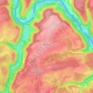
Nom : Carte topographique Berdorf, altitude, relief.
Lieu : Berdorf, Canton Echternach, Luxembourg (49.79136 6.31131 49.85077 6.38952)
Altitude moyenne : 300 m
Altitude minimum : 159 m
Altitude maximum : 396 m
Autres cartes topographiques
Cliquez sur une carte pour visualiser sa topographie, son altitude et son relief.
Mullerthal
Luxembourg > Canton Echternach > Waldbillig
Mullerthal, Waldbillig, Canton Echternach, 6245, Luxembourg
Altitude moyenne : 313 m
Altrier
Luxembourg > Canton Echternach > Altrier
Altrier, Bech, Canton Echternach, 6225, Luxembourg
Altitude moyenne : 343 m
Echternach
Luxembourg > Canton Echternach
Echternach, Canton Echternach, Luxembourg
Altitude moyenne : 284 m