Géolocaliser

Carte topographique Swansea

Carte interactive

Cliquez sur la carte pour afficher l’altitude.

À propos de cette carte

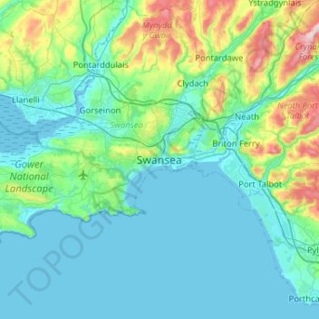
Nom : Carte topographique Swansea, altitude, relief.

Lieu : Swansea, Wales, SA1 3BN, United Kingdom (51.45960 -4.10592 51.77960 -3.78592)

Altitude moyenne : 73 m

Altitude minimum : -2 m

Altitude maximum : 464 m

Much of Swansea is hilly with the main area of upland being located in the council ward of Mawr. Areas up to 185 metres (607 ft) in elevation range across the central section: Kilvey Hill, Townhill and Llwynmawr separate the centre of Swansea from its northern suburbs. Cefn Bryn, a ridge of high land, is the backbone of the Gower Peninsula. Rhossili Down, Hardings Down and Llanmadoc Hill are up to 193 metres (633 ft) high. The highest point is located Penlle'r Castell at 374 metres (1,227 ft) on the northern border with Carmarthenshire.

Wikipedia (CC-BY-SA 3.0)

Autres cartes topographiques

Cliquez sur une carte pour visualiser sa topographie, son altitude et son relief.

Penrice

United Kingdom > Wales > Swansea

Penrice, Swansea, Wales, United Kingdom

Altitude moyenne : 55 m

Thistleboon

United Kingdom > Wales > Swansea > Mumbles > Thistleboon

Thistleboon, Mumbles, Swansea, Wales, SA3 4, United Kingdom

Altitude moyenne : 16 m