
Carte topographique Boise
Carte interactive
Cliquez sur la carte pour afficher l’altitude.
Boise
Boise (/bwaz/, en anglais : /ˈbɔɪ.si/) est une ville des États-Unis et la capitale de l'État de l'Idaho. C'est également le siège du comté d'Ada. Elle se situe dans la vallée de la Snake, à 740 km à l’est de Portland et à une altitude de 830 m. Traversée par la rivière du même nom, elle est bordée par le massif de la Sawtooth Mountain Range, au nord, par les monts Owyhee au sud, et par le plateau du Columbia et les Blue Mountains à l'ouest. En 2013, la ville de Boise abritait 214 237 habitants et 663 680 en 2016 avec l’agglomération, ce qui en fait la ville la plus peuplée de l'État.
À propos de cette carte
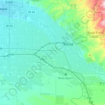
Nom : Carte topographique Boise, altitude, relief.
Lieu : Boise, Ada County, Idaho, États-Unis d'Amérique (43.50940 -116.36568 43.69206 -116.09419)
Altitude moyenne : 974 m
Altitude minimum : 779 m
Altitude maximum : 1.951 m