Carte topographique St Albans
Carte interactive
Cliquez sur la carte pour afficher l’altitude.
À propos de cette carte
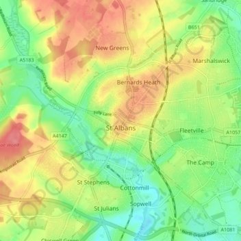
Nom : Carte topographique St Albans, altitude, relief.
Lieu : St Albans, Hertfordshire, England, United Kingdom (51.72913 -0.37529 51.78007 -0.29102)
Altitude moyenne : 103 m
Altitude minimum : 69 m
Altitude maximum : 141 m
The borough consisted of the ancient parish of St Albans (also known as the Abbey parish) and parts of the parishes of St Michael and St Peter. The borough was reformed by the Municipal Corporations Act 1835 to become a municipal borough, and the boundary was adjusted to additionally include part of the parish of St Stephen. On 28 August 1877 the borough gained city status, following the elevation of St Albans Abbey to become a cathedral. The boundary was also adjusted in 1877 to include part of the parish of Sandridge.
Autres cartes topographiques
Cliquez sur une carte pour visualiser sa topographie, son altitude et son relief.
St Albans
United Kingdom > England > Hertfordshire > St Albans
St Albans, Hertfordshire, East of England, England, United Kingdom
Altitude moyenne : 100 m
Watford
United Kingdom > England > Hertfordshire
Watford, Hertfordshire, England, United Kingdom
Altitude moyenne : 77 m
Potters Bar
United Kingdom > England > Hertfordshire > Hertsmere
Potters Bar, Hertsmere, Hertfordshire, England, EN6 1QG, United Kingdom
Altitude moyenne : 98 m
Welwyn Garden City
United Kingdom > England > Hertfordshire > Welwyn Hatfield
Welwyn Garden City, Welwyn Hatfield, Hertfordshire, England, AL8 6TP, United Kingdom
Altitude moyenne : 89 m
Hemel Hempstead
United Kingdom > England > Hertfordshire > Dacorum
Hemel Hempstead, Dacorum, Hertfordshire, England, HP1 1EW, United Kingdom
Altitude moyenne : 130 m
Hitchin
United Kingdom > England > Hertfordshire > North Hertfordshire
Hitchin, North Hertfordshire, Hertfordshire, England, SG5 1BB, United Kingdom
Altitude moyenne : 91 m
Puttenham
United Kingdom > England > Hertfordshire > Dacorum
Puttenham, Dacorum, Hertfordshire, England, HP23 4PR, United Kingdom
Altitude moyenne : 89 m
South Mimms
United Kingdom > England > Hertfordshire > Hertsmere
South Mimms, Hertsmere, Hertfordshire, England, EN6 3PL, United Kingdom
Altitude moyenne : 102 m
Connaught Park
United Kingdom > England > Hertfordshire > Hertsmere
Connaught Park, Hertsmere, Hertfordshire, England, WD23 2RA, United Kingdom
Altitude moyenne : 82 m
Wigginton
United Kingdom > England > Hertfordshire > Dacorum > Wigginton
Wigginton, Dacorum, Hertfordshire, England, United Kingdom
Altitude moyenne : 174 m
Bricket Wood
United Kingdom > England > Hertfordshire > St Albans
Bricket Wood, St Albans, Hertfordshire, England, AL2 3QS, United Kingdom
Altitude moyenne : 82 m
Astonbury Wood
United Kingdom > England > Hertfordshire > East Hertfordshire > Aston
Astonbury Wood, Aston, East Hertfordshire, Hertfordshire, England, United Kingdom
Altitude moyenne : 83 m
Old Dean
United Kingdom > England > Hertfordshire > Dacorum > Bovingdon
Old Dean, Bovingdon, Felden, Dacorum, Hertfordshire, England, United Kingdom
Altitude moyenne : 144 m
Tudor Estate
United Kingdom > England > Hertfordshire > Watford
Tudor Estate, Watford, Hertfordshire, England, WD24 7NS, United Kingdom
Altitude moyenne : 76 m
Stanstead St Margarets
United Kingdom > England > Hertfordshire > East Hertfordshire
Stanstead St Margarets, East Hertfordshire, Hertfordshire, England, SG12 8DH, United Kingdom
Altitude moyenne : 48 m
Stevenage
United Kingdom > England > Hertfordshire
Stevenage, Hertfordshire, England, United Kingdom
Altitude moyenne : 108 m
Burnham Green
United Kingdom > England > Hertfordshire > East Hertfordshire
Burnham Green, East Hertfordshire, Hertfordshire, England, AL6 0HA, United Kingdom
Altitude moyenne : 102 m
Graveley
United Kingdom > England > Hertfordshire > North Hertfordshire
Graveley, North Hertfordshire, Hertfordshire, England, United Kingdom
Altitude moyenne : 110 m
Furneux Pelham
United Kingdom > England > Hertfordshire > East Hertfordshire
Furneux Pelham, East Hertfordshire, Hertfordshire, England, United Kingdom
Altitude moyenne : 113 m
Chapmore End
United Kingdom > England > Hertfordshire > East Hertfordshire > Tonwell
Chapmore End, Bengeo Rural, Tonwell, East Hertfordshire, Hertfordshire, England, SG12 0HF, United Kingdom
Altitude moyenne : 65 m
Benington
United Kingdom > England > Hertfordshire > East Hertfordshire
Benington, East Hertfordshire, Hertfordshire, England, SG2 7LA, United Kingdom
Altitude moyenne : 106 m
Little Heath
United Kingdom > England > Hertfordshire > Dacorum > Potten End
Little Heath, Nettleden with Potten End, Potten End, Dacorum, Hertfordshire, England, HP4 2RX, United Kingdom
Altitude moyenne : 138 m
King's Meads
United Kingdom > England > Hertfordshire > East Hertfordshire > Ware
King's Meads, Glaxo Footbridge, Kings Hill, Ware, East Hertfordshire, Hertfordshire, England, SG12 0GG, United Kingdom
Altitude moyenne : 53 m
Weston
United Kingdom > England > Hertfordshire > North Hertfordshire
Weston, North Hertfordshire, Hertfordshire, England, United Kingdom
Altitude moyenne : 126 m
St Ippolyts
United Kingdom > England > Hertfordshire > North Hertfordshire
St Ippolyts, North Hertfordshire, Hertfordshire, England, United Kingdom
Altitude moyenne : 103 m
Broken Green
United Kingdom > England > Hertfordshire > East Hertfordshire
Broken Green, Standon, East Hertfordshire, Hertfordshire, England, SG11 1NH, United Kingdom
Altitude moyenne : 97 m
Highfield Park
United Kingdom > England > Hertfordshire > St Albans > Colney Heath
Highfield Park, Colney Heath, St Albans, Hertfordshire, England, United Kingdom
Altitude moyenne : 87 m
Borehamwood
United Kingdom > England > Hertfordshire > Hertsmere
Borehamwood, Hertsmere, Hertfordshire, England, WD6 5HL, United Kingdom
Altitude moyenne : 104 m
Moorend
United Kingdom > England > Hertfordshire > Dacorum > Corner Hall
Moorend, Corner Hall, Dacorum, Hertfordshire, England, HP1 1JP, United Kingdom
Altitude moyenne : 121 m
Norton
United Kingdom > England > Hertfordshire > Letchworth
Norton, Letchworth, Hertfordshire, England, SG6 1AG, United Kingdom
Altitude moyenne : 75 m
Letchworth
United Kingdom > England > Hertfordshire > North Hertfordshire > Letchworth
Letchworth, North Hertfordshire, Hertfordshire, East of England, England, SG6 3BF, United Kingdom
Altitude moyenne : 80 m
Little Amwell
United Kingdom > England > Hertfordshire > East Hertfordshire
Little Amwell, East Hertfordshire, Hertfordshire, England, SG13 7QX, United Kingdom
Altitude moyenne : 65 m
Moxon Avenue Open Space
United Kingdom > England > Hertfordshire > Cheshunt
Moxon Avenue Open Space, Cheshunt, Broxbourne, Hertfordshire, England, United Kingdom
Altitude moyenne : 25 m
Hinxworth
United Kingdom > England > Hertfordshire > North Hertfordshire
Hinxworth, North Hertfordshire, Hertfordshire, England, United Kingdom
Altitude moyenne : 48 m
Amwell
United Kingdom > England > Hertfordshire > St Albans > Wheathampstead
Amwell, Wheathampstead, St Albans, Hertfordshire, England, AL4 8EB, United Kingdom
Altitude moyenne : 106 m
Great Ashby
United Kingdom > England > Hertfordshire > North Hertfordshire
Great Ashby, North Hertfordshire, Hertfordshire, England, United Kingdom
Altitude moyenne : 134 m
Spellbrook
United Kingdom > England > Hertfordshire > East Hertfordshire > Sawbridgeworth
Spellbrook, Sawbridgeworth, East Hertfordshire, Hertfordshire, England, CM23 4RE, United Kingdom
Altitude moyenne : 71 m
Westmill
United Kingdom > England > Hertfordshire > East Hertfordshire
Westmill, East Hertfordshire, Hertfordshire, England, United Kingdom
Altitude moyenne : 108 m
Hertingfordbury
United Kingdom > England > Hertfordshire > East Hertfordshire
Hertingfordbury, East Hertfordshire, Hertfordshire, England, SG14 2LD, United Kingdom
Altitude moyenne : 61 m
Whitwell
United Kingdom > England > Hertfordshire > North Hertfordshire
Whitwell, North Hertfordshire, Hertfordshire, England, SG4 8AN, United Kingdom
Altitude moyenne : 122 m
Knebworth Country Park
United Kingdom > England > Hertfordshire > North Hertfordshire > Knebworth
Knebworth Country Park, Knebworth, Old Knebworth, North Hertfordshire, Hertfordshire, England, United Kingdom
Altitude moyenne : 116 m
Aston
United Kingdom > England > Hertfordshire > East Hertfordshire
Aston, East Hertfordshire, Hertfordshire, England, United Kingdom
Altitude moyenne : 99 m
Bishop's Stortford
United Kingdom > England > Hertfordshire > East Hertfordshire
Bishop's Stortford, East Hertfordshire, Hertfordshire, England, United Kingdom
Altitude moyenne : 83 m
Northchurch
United Kingdom > England > Hertfordshire > Dacorum > Northchurch
Northchurch, Dacorum, Hertfordshire, England, United Kingdom
Altitude moyenne : 162 m
Ayot St Peter
United Kingdom > England > Hertfordshire > Welwyn Hatfield > Welwyn Garden City
Ayot St Peter, Welwyn Garden City, Welwyn Hatfield, Hertfordshire, England, United Kingdom
Altitude moyenne : 103 m
Tringford Reservoir
United Kingdom > England > Hertfordshire > Dacorum > Tring > Wilstone
Tringford Reservoir, Tring, Wilstone, Dacorum, Hertfordshire, England, United Kingdom
Altitude moyenne : 119 m
Gobions Pond
United Kingdom > England > Hertfordshire > Welwyn Hatfield > Brookmans Park > Swanley Bar
Gobions Pond, Swanley Bar, North Mymms, Brookmans Park, Welwyn Hatfield, Hertfordshire, England, United Kingdom
Altitude moyenne : 106 m
Hatfield
United Kingdom > England > Hertfordshire > Welwyn Hatfield
Hatfield, Welwyn Hatfield, Hertfordshire, England, United Kingdom
Altitude moyenne : 90 m
Blackmore End
United Kingdom > England > Hertfordshire > St Albans > Wheathampstead
Blackmore End, Wheathampstead, St Albans, Hertfordshire, England, AL4 8LX, United Kingdom
Altitude moyenne : 114 m
Wymondley
United Kingdom > England > Hertfordshire > North Hertfordshire > Little Wymondley
Wymondley, Little Wymondley, North Hertfordshire, Hertfordshire, England, United Kingdom
Altitude moyenne : 96 m