
Carte topographique Trieste
Carte interactive
Cliquez sur la carte pour afficher l’altitude.
Trieste
Étant donné les particularités du territoire de sa province, il peut être dit que, tandis que le centre de Trieste développe le long de la côte, des températures relativement douces et un bon ensoleillement, les villages et localités karstiques subissent, sur le plateau arrière à une hauteur de deux cents à cinq cents mètres d’altitude, un climat beaucoup plus continental. À Basovizza, située à environ 370 mètres d’altitude, la température moyenne annuelle est d'environ 11 °C, avec une moyenne du mois le plus froid (janvier) de 1,5 °C et du mois le plus chaud (juillet) de 20,6 °C.
À propos de cette carte
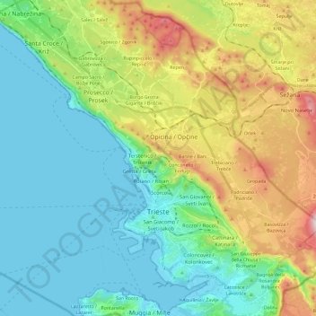
Nom : Carte topographique Trieste, altitude, relief.
Lieu : Trieste, Frioul-Vénétie julienne, 34121-34151, Italie (45.60680 13.66832 45.74662 13.89831)
Altitude moyenne : 184 m
Altitude minimum : -1 m
Altitude maximum : 647 m
Autres cartes topographiques
Cliquez sur une carte pour visualiser sa topographie, son altitude et son relief.
Naron
Italie > Frioul-Vénétie julienne > Trieste > Trieste > Prosecco / Prosek
Altitude moyenne : 239 m
Duino / Devin
Italie > Frioul-Vénétie julienne > Trieste > Duino Aurisina / Devin - Nabrežina
Altitude moyenne : 47 m