Carte topographique Cave Creek
Carte interactive
Cliquez sur la carte pour afficher l’altitude.
À propos de cette carte
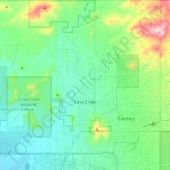
Nom : Carte topographique Cave Creek, altitude, relief.
Lieu : Cave Creek, Maricopa County, Arizona, United States (33.78831 -112.03051 33.90062 -111.90861)
Altitude moyenne : 743 m
Altitude minimum : 555 m
Altitude maximum : 1.363 m
Cave Creek is a town in the Sonoran Desert. It sits in northern Maricopa County on the northern edge of Paradise Valley, with mountains rising to the north that eventually connect with the New River Mountains and the Black Hills. It is 33 miles (53 km) north of downtown Phoenix, although the Phoenix city limits extend north to Cave Creek's southern border. The town is bordered to the east by the town of Carefree, to the west by unincorporated New River, and to the north by Tonto National Forest. Elephant Mountain rises to an elevation of 3,926 feet (1,197 m) in the northernmost part of the town. Local landmark Black Mountain, elevation 3,398 feet (1,036 m), is in the southern part of town on the border with Carefree.
Autres cartes topographiques
Cliquez sur une carte pour visualiser sa topographie, son altitude et son relief.
Phoenix
United States > Arizona > Maricopa County
Phoenix, Maricopa County, Arizona, United States
Altitude moyenne : 481 m
Peoria
United States > Arizona > Maricopa County
Peoria, Maricopa County, Arizona, United States
Altitude moyenne : 505 m
Carefree
United States > Arizona > Maricopa County
Carefree, Maricopa County, Arizona, 85377, United States
Altitude moyenne : 747 m
Scottsdale
United States > Arizona > Maricopa County > Scottsdale
Scottsdale, Maricopa County, Arizona, 85251, United States
Altitude moyenne : 414 m
El Mirage
United States > Arizona > Maricopa County
El Mirage, Maricopa County, Arizona, 85335, United States
Altitude moyenne : 344 m
New River Mesa
United States > Arizona > Maricopa County
New River Mesa, Maricopa County, Arizona, United States
Altitude moyenne : 1.199 m
Anthem
United States > Arizona > Maricopa County > Anthem
Anthem, Maricopa County, Arizona, United States
Altitude moyenne : 580 m
Paradise Valley
United States > Arizona > Maricopa County
Paradise Valley, Maricopa County, Arizona, United States
Altitude moyenne : 428 m
Mesa
United States > Arizona > Maricopa County
Mesa, Maricopa County, Arizona, United States
Altitude moyenne : 385 m
Stanwix
United States > Arizona > Maricopa County
Stanwix, Maricopa County, Arizona, United States
Altitude moyenne : 166 m
Canyon Lake
United States > Arizona > Maricopa County
Canyon Lake, Maricopa County, Arizona, United States
Altitude moyenne : 658 m
Camelback Mountain
United States > Arizona > Maricopa County > Phoenix
Camelback Mountain, Phoenix, Maricopa County, Arizona, 85018, United States
Altitude moyenne : 462 m
Scottsdale
United States > Arizona > Maricopa County
Scottsdale, Maricopa County, Arizona, United States
Altitude moyenne : 553 m
White Peak
United States > Arizona > Maricopa County > Peoria
White Peak, Peoria, Maricopa County, Arizona, United States
Altitude moyenne : 480 m
Buckeye
United States > Arizona > Maricopa County
Buckeye, Maricopa County, Arizona, United States
Altitude moyenne : 396 m
Piestewa Peak
United States > Arizona > Maricopa County > Phoenix
Piestewa Peak, Phoenix, Maricopa County, Arizona, 85036, United States
Altitude moyenne : 499 m
Sun City
United States > Arizona > Maricopa County > Peoria
Sun City, Peoria, Maricopa County, Arizona, 85351, United States
Altitude moyenne : 356 m
Phoenix
United States > Arizona > Maricopa County > Phoenix
Phoenix, Maricopa County, Arizona, 85004-1905, United States
Altitude moyenne : 368 m
Saddle
United States > Arizona > Maricopa County > Saddle
Saddle, Maricopa County, Arizona, United States
Altitude moyenne : 220 m
Tempe
United States > Arizona > Maricopa County > Tempe
Tempe, Maricopa County, Arizona, 85281, United States
Altitude moyenne : 386 m
Agua Caliente
United States > Arizona > Maricopa County
Agua Caliente, Maricopa County, Arizona, United States
Altitude moyenne : 160 m
Gateway Trailhead
United States > Arizona > Maricopa County > Scottsdale
Gateway Trailhead, Scottsdale, Maricopa County, Arizona, 85255, United States
Altitude moyenne : 530 m
Surprise
United States > Arizona > Maricopa County > Surprise
Surprise, Maricopa County, Arizona, 85374, United States
Altitude moyenne : 410 m
Mesa
United States > Arizona > Maricopa County > Mesa
Mesa, Maricopa County, Arizona, 85201, United States
Altitude moyenne : 399 m
Glendale
United States > Arizona > Maricopa County
Glendale, Maricopa County, Arizona, United States
Altitude moyenne : 380 m
Chandler
United States > Arizona > Maricopa County
Chandler, Maricopa County, Arizona, United States
Altitude moyenne : 372 m
Goodyear
United States > Arizona > Maricopa County
Goodyear, Maricopa County, Arizona, United States
Altitude moyenne : 358 m
Tempe
United States > Arizona > Maricopa County
Tempe, Maricopa County, Arizona, United States
Altitude moyenne : 370 m
Gilbert
United States > Arizona > Maricopa County
Gilbert, Maricopa County, Arizona, United States
Altitude moyenne : 383 m
Avondale
United States > Arizona > Maricopa County
Avondale, Maricopa County, Arizona, United States
Altitude moyenne : 339 m