
Carte topographique Naples
Carte interactive
Cliquez sur la carte pour afficher l’altitude.
Naples
Naples se trouve au sud-ouest de l'Italie, à 230 km au sud-est de Rome, à mi-chemin entre deux régions volcaniques, celle du Vésuve et celle des champs Phlégréens, à une altitude de 17 m sur la côte du golfe de Naples. Située au bord de la mer, Naples a depuis longtemps été un carrefour méditerranéen incontournable et est le point de départ de nombreux ferries pour les îles environnantes mais aussi pour la Sardaigne, la Sicile, les îles Éoliennes, les îles Pontines, la Corse et la Tunisie. Le territoire de Naples est composé de nombreuses collines (Vomero 250 m, Capodimonte 150 m, Posilippo 78 m, Camaldoli, la plus haute atteignant 452 m), mais aussi d'îles (Nisida, Gaiola, îles Phlégréennes) et de péninsules (baie de Trentaremi) surplombant la mer Tyrrhénienne.
À propos de cette carte
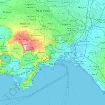
Nom : Carte topographique Naples, altitude, relief.
Lieu : Naples, Napoli, Campanie, Italie (40.79119 14.13210 40.91612 14.35377)
Altitude moyenne : 65 m
Altitude minimum : -2 m
Altitude maximum : 457 m
Autres cartes topographiques
Cliquez sur une carte pour visualiser sa topographie, son altitude et son relief.
Vésuve
Italie > Campanie > Napoli > Trecase
Le Vésuve ou mont Vésuve (monte Vesuvio en italien, Vesuvius mons en latin) est un volcan italien d'une altitude de 1 281 mètres, bordant la baie de Naples, à l'est de la ville. Il s'agit du seul volcan d'Europe continentale à être entré en éruption durant les cent dernières années, sa dernière…
Altitude moyenne : 862 m
Naples
Italie > Campanie > Napoli > Naples
Naples se trouve au sud-ouest de l'Italie, à 230 km au sud-est de Rome, à mi-chemin entre deux régions volcaniques, celle du Vésuve et celle des champs Phlégréens, à une altitude de 17 m sur la côte du golfe de Naples. Située au bord de la mer, Naples a depuis longtemps été un carrefour…
Altitude moyenne : 58 m