Géolocaliser

Carte topographique Portimão

Carte interactive

Cliquez sur la carte pour afficher l’altitude.

À propos de cette carte

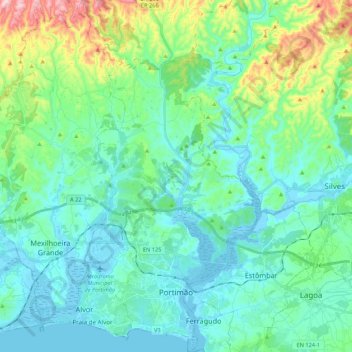
Nom : Carte topographique Portimão, altitude, relief.

Lieu : Portimão, Faro, Portugal (37.10842 -8.68466 37.27992 -8.48520)

Altitude moyenne : 67 m

Altitude minimum : -8 m

Altitude maximum : 332 m

The geographical distribution of the altitude and relief of the municipality of Portimão generically follow the three types of territory present in the Barlavento: the coastal region, the Barrocal (a region between the coastal region and the mountains) and the mountains up north. Each one with their own geological, morphological and pedagogical characteristics.

Wikipedia (CC-BY-SA 3.0)

Autres cartes topographiques

Cliquez sur une carte pour visualiser sa topographie, son altitude et son relief.

Altura

Portugal > Faro > Castro Marim

Altura, Castro Marim, Faro, Portugal

Altitude moyenne : 23 m

Faro

Portugal > Faro > Faro

Faro, Portugal

Altitude moyenne : 67 m

Quarteira

Portugal > Faro > Quarteira

Quarteira, Loulé, Faro, Portugal

Altitude moyenne : 29 m

Loulé

Portugal > Faro

Loulé, Faro, Portugal

Altitude moyenne : 206 m

Albufeira

Portugal > Faro

Albufeira, Faro, Portugal

Altitude moyenne : 77 m