
Faire un don
Équipez-vous pour votre prochaine aventure :
En tant que Partenaire Amazon, ce site perçoit une commission sur les achats éligibles sans surcoût pour vous.
Carte topographique Citlaltépetl
Cliquez sur la carte pour afficher l’altitude.
Faire un don
Équipez-vous pour votre prochaine aventure :
En tant que Partenaire Amazon, ce site perçoit une commission sur les achats éligibles sans surcoût pour vous.
Citlaltépetl
The municipality of Citlaltépetl is located in central Veracruz at an altitude between 80 and 1,300 metres (260–4,270 ft), with the south being higher in elevation. It borders the municipalities of Ozuluama to the northwest, Tantima to the northeast and east, Tancoco to the southeast, and Chontla to the west. The municipality covers an area of 81.539 square kilometres (31.482 sq mi) and comprises 0.1% of the state's area.
Faire un don
Équipez-vous pour votre prochaine aventure :
En tant que Partenaire Amazon, ce site perçoit une commission sur les achats éligibles sans surcoût pour vous.
À propos de cette carte
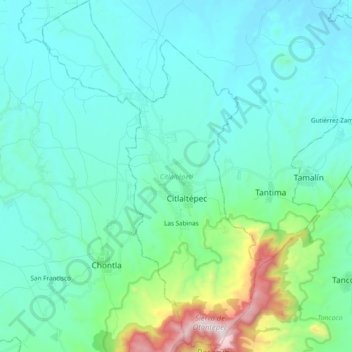
Nom : Carte topographique Citlaltépetl, altitude, relief.
Lieu : Citlaltépetl, Veracruz, Mexico (21.25009 -97.95728 21.42760 -97.83784)
Altitude moyenne : 224 m
Altitude minimum : 27 m
Altitude maximum : 1.258 m
Faire un don
Équipez-vous pour votre prochaine aventure :
En tant que Partenaire Amazon, ce site perçoit une commission sur les achats éligibles sans surcoût pour vous.
Autres cartes topographiques
Cliquez sur une carte pour visualiser sa topographie, son altitude et son relief.
Córdoba
Córdoba is located in the center of the state of Veracruz, at 18º51'30" north latitude and 96º55'51" west longitude. It lies between the hills of Matlaquiahitl and Tepixtepec, at an elevation of 817 meters (2,680 feet) above mean sea level.
Altitude moyenne : 1.030 m
Faire un don
Équipez-vous pour votre prochaine aventure :
En tant que Partenaire Amazon, ce site perçoit une commission sur les achats éligibles sans surcoût pour vous.
Fraccionamiento Ciudad Olmeca
Mexico > Veracruz > Coatzacoalcos > Fraccionamiento Ciudad Olmeca
Altitude moyenne : 6 m