Carte topographique Cache County
Carte interactive
Cliquez sur la carte pour afficher l’altitude.
À propos de cette carte
![Carte topographique Cache County, altitude, relief](/pub/maps/relation/sb18/sbgg18/thumbnail.jpg)
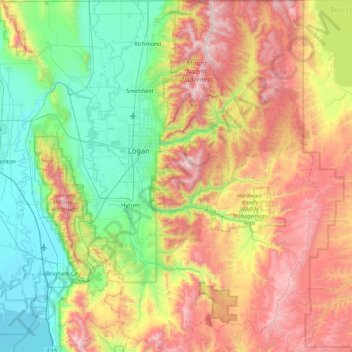
Nom : Carte topographique Cache County, altitude, relief.
Lieu : Cache County, Utah, United States (41.36882 -112.16611 41.99955 -111.40158)
Altitude moyenne : 1.906 m
Altitude minimum : 1.279 m
Altitude maximum : 3.003 m
Cache County lies on the north edge of Utah. Its north border abuts the south border of the state of Idaho. On the western edge of the county are the Wellsville Mountains and on the eastern edge are the Bear River Mountains, both northern branches of the Wasatch Range. The Cache Valley reaches north to the state border. The Bear River Mountains, the northernmost extension of the Wasatch Range, cover the eastern half of the county. The county's highest elevation is Naomi Peak in the northeast part of the county, at 9,979 feet (3,042 m) above sea level. The Bear River flows through Cache Valley. The county has a total area of 1,173 square miles (3,040 km2), of which 1,165 square miles (3,020 km2) is land and 8.2 square miles (21 km2) (0.7%) is water.
Autres cartes topographiques
Cliquez sur une carte pour visualiser sa topographie, son altitude et son relief.
![Carte topographique Park City, altitude, relief](/pub/maps/relation/kbz4/s47dn/icon.jpg)
Park City
United States > Utah > Summit County
Park City, Summit County, Utah, United States
Altitude moyenne : 2.290 m
![Carte topographique Provo, altitude, relief](/pub/maps/relation/87rr/kf518/icon.jpg)
Provo
United States > Utah > Utah County
Provo, Utah County, Utah, United States
Altitude moyenne : 1.728 m
![Carte topographique Moab, altitude, relief](/pub/maps/relation/b23l/6sbz4/icon.jpg)
Moab
United States > Utah > Grand County
Moab, Grand County, Utah, 84532, United States
Altitude moyenne : 1.357 m
![Carte topographique Ogden, altitude, relief](/pub/maps/relation/gczs/jw157/icon.jpg)
Ogden
United States > Utah > Weber County
Ogden, Weber County, Utah, United States
Altitude moyenne : 1.498 m
![Carte topographique Cedar City, altitude, relief](/pub/maps/relation/ct5k/w7q3l/icon.jpg)
Cedar City
United States > Utah > Iron County
Cedar City, Iron County, Utah, United States
Altitude moyenne : 1.975 m
![Carte topographique Manti, altitude, relief](/pub/maps/relation/wqb3/lmkmt/icon.jpg)
Manti
United States > Utah > Sanpete County
Manti, Sanpete County, Utah, 84642, United States
Altitude moyenne : 1.743 m
![Carte topographique Bryce Canyon City, altitude, relief](/pub/maps/relation/zp57/f8wtp/icon.jpg)
Bryce Canyon City
United States > Utah > Garfield County
Bryce Canyon City, Garfield County, Utah, 84764, United States
Altitude moyenne : 2.336 m
![Carte topographique Lapoint, altitude, relief](/pub/maps/node/wf3/x5q9f3l/icon.jpg)
Lapoint
United States > Utah > Uintah County
Lapoint, Uintah County, Utah, 84039, United States
Altitude moyenne : 1.710 m
![Carte topographique Virgin, altitude, relief](/pub/maps/relation/6bgp/mt6m2/icon.jpg)
Virgin
United States > Utah > Washington County
Virgin, Washington County, Utah, United States
Altitude moyenne : 1.251 m
![Carte topographique Providence Canyon, altitude, relief](/pub/maps/node/w15k/fqnbqxcz/icon.jpg)
Providence Canyon
United States > Utah > Cache County
Providence Canyon, Cache County, Utah, 84332, United States
Altitude moyenne : 1.829 m
![Carte topographique Woodland Hills, altitude, relief](/pub/maps/relation/b53l/6s7z4/icon.jpg)
Woodland Hills
United States > Utah > Utah County
Woodland Hills, Utah County, Utah, United States
Altitude moyenne : 1.812 m
![Carte topographique Farr West, altitude, relief](/pub/maps/relation/qqt6/7l79m/icon.jpg)
Farr West
United States > Utah > Weber County
Farr West, Weber County, Utah, United States
Altitude moyenne : 1.313 m
![Carte topographique Fruitland, altitude, relief](/pub/maps/node/9kf3/w5qkdtf/icon.jpg)
Fruitland
United States > Utah > Duchesne County
Fruitland, Duchesne County, Utah, 84027, United States
Altitude moyenne : 2.028 m
![Carte topographique Saratoga Springs, altitude, relief](/pub/maps/relation/sl51/t2p3q/icon.jpg)
Saratoga Springs
United States > Utah > Utah County
Saratoga Springs, Utah County, Utah, 84045, United States
Altitude moyenne : 1.500 m
![Carte topographique Mount Timpanogos, altitude, relief](/pub/maps/node/72z4/3x6vdd51/icon.jpg)
Mount Timpanogos
United States > Utah > Utah County
Mount Timpanogos, Utah County, Utah, 84602, United States
Altitude moyenne : 3.139 m
![Carte topographique Echo, altitude, relief](/pub/maps/node/d4kl/5z2gq57/icon.jpg)
Echo
United States > Utah > Summit County
Echo, Summit County, Utah, 84024, United States
Altitude moyenne : 1.792 m
![Carte topographique Draper, altitude, relief](/pub/maps/relation/hm3q/qgc5k/icon.jpg)
Draper
United States > Utah > Salt Lake County
Draper, Salt Lake County, Utah, 84020, United States
Altitude moyenne : 1.573 m
![Carte topographique Bryce Canyon National Park, altitude, relief](/pub/maps/relation/hqrr/fz9k14/icon.jpg)
Bryce Canyon National Park
United States > Utah > Garfield County
Bryce Canyon National Park, Garfield County, Utah, United States
Altitude moyenne : 2.259 m
![Carte topographique Elk Ridge, altitude, relief](/pub/maps/relation/67gp/mt8m2/icon.jpg)
Elk Ridge
United States > Utah > Utah County
Elk Ridge, Utah County, Utah, United States
Altitude moyenne : 1.698 m
![Carte topographique Springdale, altitude, relief](/pub/maps/relation/791h/f86gp/icon.jpg)
Springdale
United States > Utah > Washington County
Springdale, Washington County, Utah, 84767, United States
Altitude moyenne : 1.354 m
![Carte topographique Malad River, altitude, relief](/pub/maps/way/xtf/m4jgj91h/icon.jpg)
Malad River
United States > Utah > Box Elder County
Malad River, Box Elder County, Utah, 84301, United States
Altitude moyenne : 1.295 m
![Carte topographique Bel-Mar Acres, altitude, relief](/pub/maps/node/9ss8/f7kcp1h/icon.jpg)
Bel-Mar Acres
United States > Utah > Weber County > South Ogden
Bel-Mar Acres, South Ogden, Weber County, Utah, 84408, United States
Altitude moyenne : 1.375 m
![Carte topographique Upheaval Dome, altitude, relief](/pub/maps/node/1s3q/7343brr/icon.jpg)
Upheaval Dome
United States > Utah > San Juan County
Upheaval Dome, San Juan County, Utah, United States
Altitude moyenne : 1.627 m
![Carte topographique Washington County, altitude, relief](/pub/maps/relation/hh51/nd7p51/icon.jpg)
Washington County
Washington County, Utah, United States
Altitude moyenne : 1.550 m
![Carte topographique Halchita, altitude, relief](/pub/maps/relation/7wnh/5xct6/icon.jpg)
Halchita
United States > Utah > San Juan County
Halchita, San Juan County, Utah, United States
Altitude moyenne : 1.398 m
![Carte topographique Price, altitude, relief](/pub/maps/relation/b2kl/d3wnh/icon.jpg)
Price
United States > Utah > Carbon County
Price, Carbon County, Utah, 84591, United States
Altitude moyenne : 1.711 m
![Carte topographique Centerville, altitude, relief](/pub/maps/relation/66tp/gkgtf/icon.jpg)
Centerville
United States > Utah > Davis County
Centerville, Davis County, Utah, 84014, United States
Altitude moyenne : 1.521 m
![Carte topographique Riverton, altitude, relief](/pub/maps/relation/2vnx/w7bkl/icon.jpg)
Riverton
United States > Utah > Salt Lake County
Riverton, Salt Lake County, Utah, United States
Altitude moyenne : 1.376 m
![Carte topographique Townsend, altitude, relief](/pub/maps/node/ks18/l6knjtp/icon.jpg)
Townsend
United States > Utah > Utah County > Genola
Townsend, Genola, Utah County, Utah, 84655, United States
Altitude moyenne : 1.438 m
![Carte topographique Manns Peak, altitude, relief](/pub/maps/node/qnnx/j96vj14/icon.jpg)
Manns Peak
United States > Utah > Grand County
Manns Peak, Grand County, Utah, United States
Altitude moyenne : 3.427 m
![Carte topographique Saint George, altitude, relief](/pub/maps/relation/grzs/jwv57/icon.jpg)
Saint George
United States > Utah > Washington County
Saint George, Washington County, Utah, United States
Altitude moyenne : 929 m
![Carte topographique Castle Valley, altitude, relief](/pub/maps/relation/75nh/5x1t6/icon.jpg)
Castle Valley
United States > Utah > Grand County
Castle Valley, Grand County, Utah, United States
Altitude moyenne : 1.610 m
![Carte topographique Castleton Tower, altitude, relief](/pub/maps/node/n551/spbq371h/icon.jpg)
Castleton Tower
United States > Utah > Grand County
Castleton Tower, Grand County, Utah, United States
Altitude moyenne : 1.549 m
![Carte topographique Black Mountain, altitude, relief](/pub/maps/node/qgt/mx5r7btj/icon.jpg)
Black Mountain
United States > Utah > Salt Lake County > Salt Lake City
Black Mountain, Salt Lake City, Salt Lake County, Utah, United States
Altitude moyenne : 2.250 m
![Carte topographique Black Mountain, altitude, relief](/pub/maps/node/krt6/g6llqmt/icon.jpg)
Black Mountain
United States > Utah > Rich County
Black Mountain, Rich County, Utah, United States
Altitude moyenne : 2.157 m
![Carte topographique Pleasant View, altitude, relief](/pub/maps/node/65f3/9gb2g4s/icon.jpg)
Pleasant View
United States > Utah > Utah County > Provo
Pleasant View, Provo, Utah County, Utah, 84604, United States
Altitude moyenne : 1.446 m
![Carte topographique Salina, altitude, relief](/pub/maps/relation/9r9m/kfcs8/icon.jpg)
Salina
United States > Utah > Sevier County
Salina, Sevier County, Utah, 84654, United States
Altitude moyenne : 1.637 m
![Carte topographique Salt Lake City, altitude, relief](/pub/maps/relation/wbb3/lmdmt/icon.jpg)
Salt Lake City
United States > Utah > Salt Lake County
Salt Lake City, Salt Lake County, Utah, United States
Altitude moyenne : 1.592 m
![Carte topographique Colorado Plateau, altitude, relief](/pub/maps/node/4ngp/5pz4g1h/icon.jpg)
Colorado Plateau
United States > Utah > San Juan County
Colorado Plateau, San Juan County, Utah, United States
Altitude moyenne : 1.512 m
![Carte topographique Summit Park, altitude, relief](/pub/maps/relation/2tnx/w7jkl/icon.jpg)
Summit Park
United States > Utah > Summit County
Summit Park, Summit County, Utah, United States
Altitude moyenne : 2.152 m
![Carte topographique Coalville, altitude, relief](/pub/maps/relation/g24s/lmwgt/icon.jpg)
Coalville
United States > Utah > Summit County
Coalville, Summit County, Utah, United States
Altitude moyenne : 1.825 m
![Carte topographique Heber, altitude, relief](/pub/maps/relation/ht3q/qg55k/icon.jpg)
Heber
United States > Utah > Wasatch County
Heber, Wasatch County, Utah, 84032, United States
Altitude moyenne : 1.737 m
![Carte topographique Mountains Meadows, altitude, relief](/pub/maps/node/3xmt/f7kq9nh/icon.jpg)
Mountains Meadows
United States > Utah > Davis County > North Salt Lake
Mountains Meadows, North Salt Lake, Davis County, Utah, 84054, United States
Altitude moyenne : 1.411 m