
Carte topographique Pully
Carte interactive
Cliquez sur la carte pour afficher l’altitude.
Pully
La ville de Pully est située au bord du lac Léman, à l'est de Lausanne. Elle fait partie de l'agglomération lausannoise. L'altitude de Pully varie de 375 m à 800 m (Mont-de-Pully). Deux rivières délimitent en partie Pully, la Vuachère avec Lausanne et la Paudèze avec Paudex.
À propos de cette carte
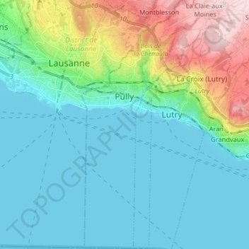
Nom : Carte topographique Pully, altitude, relief.
Lieu : Pully, District de Lavaux-Oron, Vaud, Suisse (46.45454 6.63934 46.54462 6.70218)
Altitude moyenne : 474 m
Altitude minimum : 369 m
Altitude maximum : 850 m
Autres cartes topographiques
Cliquez sur une carte pour visualiser sa topographie, son altitude et son relief.