Carte topographique Williamson County
Carte interactive
Cliquez sur la carte pour afficher l’altitude.
À propos de cette carte
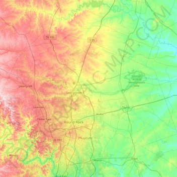
Nom : Carte topographique Williamson County, altitude, relief.
Lieu : Williamson County, Texas, United States (30.40281 -98.05005 30.90559 -97.15520)
Altitude moyenne : 222 m
Altitude minimum : 110 m
Altitude maximum : 417 m
The area is divided into two regions by the Balcones Escarpment, which runs through the center from north to south along a line from Jarrell to Georgetown to Round Rock. The county's western half is an extension of the Western Plains and considered to be within the eastern fringes of Texas Hill Country; it has an average elevation of 850 ft (260 m). It features undulating, hilly brushland with an abundance of Texas live oak, prickly pear cactus, and karst. The county's eastern half is part of the Coastal Plains and is flat to gently rolling with an average elevation of 600 ft (180 m). It has dark clay and rich, fertile soils for agriculture, but is quickly being developed as the county's population continues to increase and expand out. Williamson County is drained in the center and south by the San Gabriel River, the county's only river, and in the north by creeks that run into the Lampasas and Little Rivers north of the county line.
Autres cartes topographiques
Cliquez sur une carte pour visualiser sa topographie, son altitude et son relief.
Kingwood
United States > Texas > Harris County > Houston
Kingwood, Houston, Harris County, Texas, 77345, United States
Altitude moyenne : 22 m
Houston
United States > Texas > Harris County
Houston, Harris County, Texas, United States
Altitude moyenne : 25 m
San Antonio
United States > Texas > Bexar County
San Antonio, Bexar County, Texas, United States
Altitude moyenne : 247 m
Dallas
United States > Texas > Dallas County
Dallas, Dallas County, Texas, United States
Altitude moyenne : 160 m
Austin
United States > Texas > Travis County
Austin, Travis County, Texas, United States
Altitude moyenne : 216 m
San Angelo
United States > Texas > Tom Green County
San Angelo, Tom Green County, Texas, United States
Altitude moyenne : 576 m
Amarillo
United States > Texas > Potter County
Amarillo, Potter County, Texas, United States
Altitude moyenne : 1.097 m
Conroe
United States > Texas > Montgomery County
Conroe, Montgomery County, Texas, United States
Altitude moyenne : 62 m
Granbury
United States > Texas > Hood County
Granbury, Hood County, Texas, 76048, United States
Altitude moyenne : 242 m
New Braunfels
United States > Texas > Comal County
New Braunfels, Comal County, Texas, United States
Altitude moyenne : 228 m
Cypress
United States > Texas > Harris County
Cypress, Harris County, Texas, 77433, United States
Altitude moyenne : 46 m
El Paso
United States > Texas > El Paso County
El Paso, El Paso County, Texas, United States
Altitude moyenne : 1.237 m
Denton
United States > Texas > Denton County
Denton, Denton County, Texas, United States
Altitude moyenne : 195 m
Georgetown
United States > Texas > Williamson County
Georgetown, Williamson County, Texas, United States
Altitude moyenne : 247 m
Canyon Lake
United States > Texas > Comal County
Canyon Lake, Comal County, Texas, 78133, United States
Altitude moyenne : 296 m
Weatherford
United States > Texas > Parker County
Weatherford, Parker County, Texas, 76086, United States
Altitude moyenne : 326 m
Galveston Island
United States > Texas > Galveston County > Galveston
Galveston Island, Galveston, Galveston County, Texas, 77554, United States
Altitude moyenne : 2 m
Longview
United States > Texas > Gregg County
Longview, Gregg County, Texas, United States
Altitude moyenne : 105 m
Sugar Land
United States > Texas > Fort Bend County
Sugar Land, Fort Bend County, Texas, United States
Altitude moyenne : 24 m
Rockport
United States > Texas > Aransas County
Rockport, Aransas County, Texas, 78382, United States
Altitude moyenne : 3 m
Katy
United States > Texas > Fort Bend County
Katy, Fort Bend County, Texas, United States
Altitude moyenne : 44 m
Baytown
United States > Texas > Harris County
Baytown, Harris County, Texas, United States
Altitude moyenne : 7 m
Dripping Springs
United States > Texas > Hays County
Dripping Springs, Hays County, Texas, United States
Altitude moyenne : 356 m
Round Rock
United States > Texas > Williamson County
Round Rock, Williamson County, Texas, United States
Altitude moyenne : 242 m
Wichita Falls
United States > Texas > Wichita County
Wichita Falls, Wichita County, Texas, United States
Altitude moyenne : 300 m
Lake Travis
United States > Texas > Travis County > Lago Vista
Lake Travis, Lago Vista, Travis County, Texas, United States
Altitude moyenne : 278 m
Alpine
United States > Texas > Brewster County
Alpine, Brewster County, Texas, United States
Altitude moyenne : 1.373 m
Boerne
United States > Texas > Kendall County
Boerne, Kendall County, Texas, United States
Altitude moyenne : 465 m
Montgomery County
Montgomery County, Texas, United States
Altitude moyenne : 69 m
Galveston
United States > Texas > Galveston County
Galveston, Galveston County, Texas, United States
Altitude moyenne : 1 m
Cedar Hill
United States > Texas > Dallas County
Cedar Hill, Dallas County, Texas, 75104, United States
Altitude moyenne : 214 m
San Marcos
United States > Texas > Hays County
San Marcos, Hays County, Texas, 78666, United States
Altitude moyenne : 208 m
Beaumont
United States > Texas > Jefferson County
Beaumont, Jefferson County, Texas, United States
Altitude moyenne : 6 m
Arlington
United States > Texas > Tarrant County
Arlington, Tarrant County, Texas, United States
Altitude moyenne : 174 m
Fort Worth
United States > Texas > Tarrant County
Fort Worth, Tarrant County, Texas, United States
Altitude moyenne : 212 m
Kerrville
United States > Texas > Kerr County
Kerrville, Kerr County, Texas, United States
Altitude moyenne : 545 m
Fredericksburg
United States > Texas > Gillespie County
Fredericksburg, Gillespie County, Texas, United States
Altitude moyenne : 526 m
Waco
United States > Texas > McLennan County
Waco, McLennan County, Texas, United States
Altitude moyenne : 147 m