
Faire un don
Équipez-vous pour votre prochaine aventure :
En tant que Partenaire Amazon, ce site perçoit une commission sur les achats éligibles sans surcoût pour vous.
Carte topographique Mīrpur Sakro
Cliquez sur la carte pour afficher l’altitude.
Faire un don
Équipez-vous pour votre prochaine aventure :
En tant que Partenaire Amazon, ce site perçoit une commission sur les achats éligibles sans surcoût pour vous.
Mīrpur Sakro
Mirpur Sakro (Sindhi: ميرپورساڪرو,) is a town located 33 km away from Thatta. while it is 85 km away from Karachi. Mirpur Sakro is at an altitude of 35 meters. It is a small area having a population of around 17,500 settled in a scattered form. The native language spoken here is Sindhi. The most prominent aspects of this village is its connectivity to 88-km-long Gharo-Keti Bunder highway and the Sakro Qabrustan (graveyard) which is around 2 km wide located in the middle of the village. Mirpur Sakro is accessed by both cars and busses.
Faire un don
Équipez-vous pour votre prochaine aventure :
En tant que Partenaire Amazon, ce site perçoit une commission sur les achats éligibles sans surcoût pour vous.
À propos de cette carte
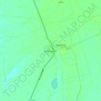
Nom : Carte topographique Mīrpur Sakro, altitude, relief.
Altitude moyenne : 5 m
Altitude minimum : 0 m
Altitude maximum : 8 m
Faire un don
Équipez-vous pour votre prochaine aventure :
En tant que Partenaire Amazon, ce site perçoit une commission sur les achats éligibles sans surcoût pour vous.
Autres cartes topographiques
Cliquez sur une carte pour visualiser sa topographie, son altitude et son relief.