
Carte topographique Ilha de Santa Maria
Carte interactive
Cliquez sur la carte pour afficher l’altitude.
Ilha de Santa Maria
Santa Maria (en portugais : Ilha de Santa Maria) est l'une des neuf îles de l'archipel des Açores. Elle se situe au sud-est de l'archipel, d'une superficie de 97 km2, ses dimensions sont d'environ 17 sur 10 kilomètres. Santa Maria culmine au Pico Alto à 590 mètres d'altitude.
À propos de cette carte
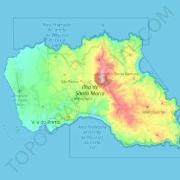
Nom : Carte topographique Ilha de Santa Maria, altitude, relief.
Altitude moyenne : 81 m
Altitude minimum : -1 m
Altitude maximum : 569 m