
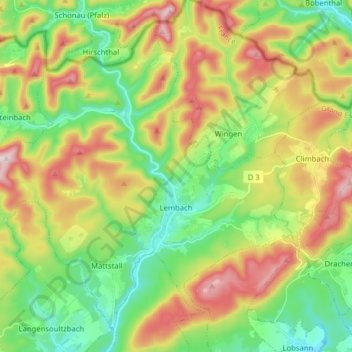
Carte topographique Lembach
Carte interactive
Cliquez sur la carte pour afficher l’altitude.
À propos de cette carte
Nom : Carte topographique Lembach, altitude, relief.
Altitude moyenne : 319 m
Altitude minimum : 169 m
Altitude maximum : 550 m
Le village est entouré de collines dont l'altitude atteint 450 à 500 m (Riegelsberg au nord-est, Kraehberg à l'ouest, Hochwald à l'est).
Autres cartes topographiques
Cliquez sur une carte pour visualiser sa topographie, son altitude et son relief.
Bassemberg
Bassemberg, Sélestat-Erstein, Bas-Rhin, Grand Est, France métropolitaine, 67220, France
Altitude moyenne : 361 m
Illkirch-Graffenstaden
Illkirch-Graffenstaden, Strasbourg, Bas-Rhin, Grand Est, France métropolitaine, 67400, France
Altitude moyenne : 144 m
Dambach-la-Ville
Dambach-la-Ville, Sélestat-Erstein, Bas-Rhin, Grand Est, France métropolitaine, 67650, France
Altitude moyenne : 259 m
Lichtenberg
Lichtenberg, Saverne, Bas-Rhin, Grand Est, France métropolitaine, 67340, France
Altitude moyenne : 279 m
Meistratzheim
Meistratzheim, Sélestat-Erstein, Bas-Rhin, Grand Est, France métropolitaine, 67210, France
Altitude moyenne : 158 m
Strasbourg
Strasbourg, Bas-Rhin, Grand Est, France métropolitaine, France
Altitude moyenne : 144 m
Stre.
France > Grand Est > Bas-Rhin > Oberlauterbach
Stre., Oberlauterbach, Haguenau-Wissembourg, Bas-Rhin, Grand Est, France métropolitaine, 67160, France
Altitude moyenne : 171 m
Orschwiller
Orschwiller, Sélestat-Erstein, Bas-Rhin, Grand Est, France métropolitaine, 67600, France
Altitude moyenne : 271 m
Engenthal
France > Grand Est > Bas-Rhin > Wangenbourg-Engenthal
Engenthal, Wangenbourg-Engenthal, Molsheim, Bas-Rhin, Grand Est, France métropolitaine, 67710, France
Altitude moyenne : 530 m
Dorlisheim
Dorlisheim, Molsheim, Bas-Rhin, Grand Est, France métropolitaine, 67120, France
Altitude moyenne : 205 m
Col du Donon
France > Grand Est > Bas-Rhin > Grandfontaine
Col du Donon, Haut Donon, Grandfontaine, Molsheim, Bas-Rhin, Grand Est, France métropolitaine, 67130, France
Altitude moyenne : 694 m
Obersteinbach
Obersteinbach, Haguenau-Wissembourg, Bas-Rhin, Grand Est, France métropolitaine, 67510, France
Altitude moyenne : 322 m
La Rothlach
France > Grand Est > Bas-Rhin > Le Hohwald
La Rothlach, Le Hohwald, Sélestat-Erstein, Bas-Rhin, Grand Est, France métropolitaine, 67140, France
Altitude moyenne : 870 m
Bouxwiller
France > Grand Est > Bas-Rhin > Bouxwiller
Bouxwiller, Saverne, Bas-Rhin, Grand Est, France métropolitaine, 67330, France
Altitude moyenne : 223 m
Le Hohwald
France > Grand Est > Bas-Rhin > Le Hohwald
Le Hohwald, Sélestat-Erstein, Bas-Rhin, Grand Est, France métropolitaine, 67140, France
Altitude moyenne : 730 m
Mittelhausbergen
France > Grand Est > Bas-Rhin > Mittelhausbergen
Mittelhausbergen, Strasbourg, Bas-Rhin, Grand Est, France métropolitaine, 67206, France
Altitude moyenne : 158 m
Mackenheim
France > Grand Est > Bas-Rhin > Mackenheim
Mackenheim, Sélestat-Erstein, Bas-Rhin, Grand Est, France métropolitaine, 67390, France
Altitude moyenne : 174 m
Muttersholtz
France > Grand Est > Bas-Rhin > Muttersholtz
Muttersholtz, Sélestat-Erstein, Bas-Rhin, Grand Est, France métropolitaine, 67600, France
Altitude moyenne : 167 m
Freudeneck
France > Grand Est > Bas-Rhin > Wangenbourg-Engenthal
Freudeneck, Wangenbourg-Engenthal, Molsheim, Bas-Rhin, Grand Est, France métropolitaine, 67710, France
Altitude moyenne : 415 m
Schœnbourg
France > Grand Est > Bas-Rhin > Schœnbourg
Schœnbourg, Saverne, Bas-Rhin, Grand Est, France métropolitaine, 67320, France
Altitude moyenne : 303 m
Breitenbach
Breitenbach, Sélestat-Erstein, Bas-Rhin, Grand Est, France métropolitaine, 67220, France
Altitude moyenne : 608 m
Saint-Pierre
Saint-Pierre, Sélestat-Erstein, Bas-Rhin, Grand Est, France métropolitaine, 67140, France
Altitude moyenne : 184 m
Preuschdorf
Preuschdorf, Haguenau-Wissembourg, Bas-Rhin, Grand Est, France métropolitaine, 67250, France
Altitude moyenne : 234 m
La Walck
France > Grand Est > Bas-Rhin > Val-de-Moder
La Walck, Val-de-Moder, Haguenau-Wissembourg, Bas-Rhin, Grand Est, France métropolitaine, 67350, France
Altitude moyenne : 189 m
Grandfontaine
Grandfontaine, Molsheim, Bas-Rhin, Grand Est, France métropolitaine, 67130, France
Altitude moyenne : 610 m
Natzwiller
Natzwiller, Molsheim, Bas-Rhin, Grand Est, France métropolitaine, 67130, France
Altitude moyenne : 705 m
Lauterbourg
Lauterbourg, Haguenau-Wissembourg, Bas-Rhin, Grand Est, France métropolitaine, 67630, France
Altitude moyenne : 118 m
La Petite-Pierre
La Petite-Pierre, Saverne, Bas-Rhin, Grand Est, France métropolitaine, 67290, France
Altitude moyenne : 314 m